Approximate Location Map
Large Map »
Latitude: 51.782 / 51°46'55"N
Longitude: -3.244 / 3°14'38"W
OS Eastings: 314278
OS Northings: 209991
OS Grid: SO142099
Mapcode National: GBR YW.YV9X
Mapcode Global: VH6CT.QGCS
Plus Code: 9C3RQQJ4+Q9
Entry Name: Former Tramroad Bridge over Sirhowy River
Listing Date: 14 October 1999
Last Amended: 14 October 1999
Grade: II
Source: Cadw
Source ID: 22497
Building Class: Transport
ID on this website: 300022497
Location: Located parallel to Dukestown Road, carrying junction of short road connecting to roundabout to S. Opposite entrance to Graham’s Yard.
County: Blaenau Gwent
Community: Tredegar
Community: Tredegar
Locality: Sirhowy
Built-Up Area: Tredegar
Traditional County: Monmouthshire
Tagged with: Tram bridge
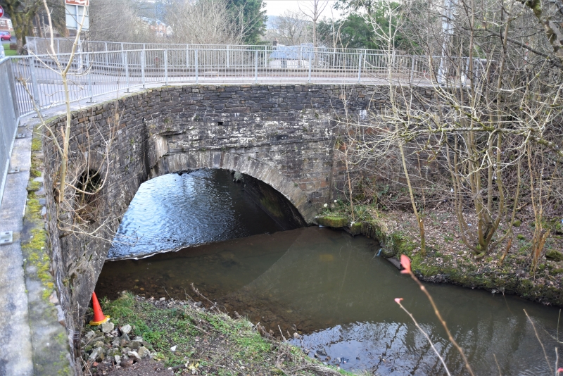
Built 1802-05. The bridge was associated with the Sirhowy Ironworks to the NE, which opened in 1778, the first in Monmouthshire to be fired by coke rather than charcoal. The lease of the site was taken that year by Thomas Atkinson, William Barrow, Bolton Hudson and John Sealy, London speculators. A square furnace was built of river stone, the bellows at first driven by hand, until a water wheel was set up in the Sirhowy river: this doubling the 4-6 tons (4.06-6.1 tonnes) weekly output. The early 1790s saw a slump in the industry, and the works were sold in 1794 to Matthew Monkhouse and Richard Fothergill, the latter eventually constructing tramways, and initiating the building of the Sirhowy-Newport tramroad in 1802-05. The bridge formed the north end of the 32 km long tramroad, the splayed deck and side arches on the E side allowing the tramroads to fan out onto the Ironworks site. Despite closure in 1882, the furnace bank of the ironworks still survive.
Rubble built. Wide segmental arch with cut stone voussoirs; projecting keystone. Stringcourse above arch. Splay-arches abutting each side of bridge to E, allowing the tramroad tracks to fan out towards the Ironworks site to the NE: these are of part-segmental form, abutting main bridge some 50 cm short of keystones. Low parapets with cement copings and C20 metal fencing above. Bridge continues towards SW as revetments; also to E and W alongside Dukestown Road.
Listed as a significant and unusual survival of the early iron industry in the Monmouthshire Valleys.
External links are from the relevant listing authority and, where applicable, Wikidata. Wikidata IDs may be related buildings as well as this specific building. If you want to add or update a link, you will need to do so by editing the Wikidata entry.


Other nearby listed buildings
