Approximate Location Map
Large Map »
Latitude: 52.687 / 52°41'13"N
Longitude: -3.7393 / 3°44'21"W
OS Eastings: 282533
OS Northings: 311345
OS Grid: SH825113
Mapcode National: GBR 97.3S03
Mapcode Global: WH682.JQMF
Plus Code: 9C4RM7P6+R7
Entry Name: Ffridd
Listing Date: 4 November 1999
Last Amended: 4 November 1999
Grade: II
Source: Cadw
Source ID: 22616
Building Class: Domestic
ID on this website: 300022616
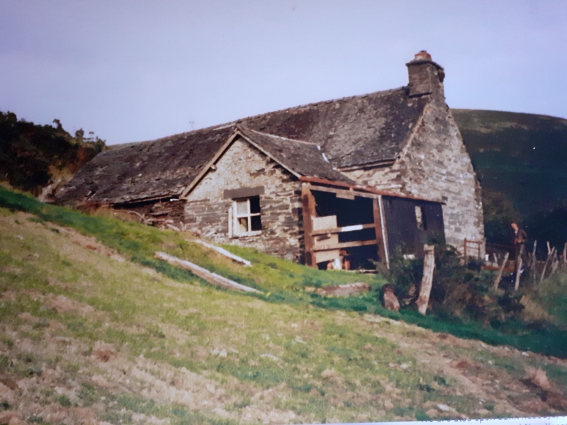
Location: The small dwelling is uphill sited on the S flank of Foel-y-fridd, some 80m above the valley bottom road along the Afon Angell.
County: Gwynedd
Town: Machynlleth
Community: Mawddwy
Community: Mawddwy
Locality: Aberangell
Traditional County: Merionethshire
Tagged with: House
The building was probably erected in the later C18 as a permanent dwelling on the encroachment into the ffridd.
The house is built of local rubble stonework, colourwashed in both red and white at various times, and grouted slate roof with rooflights. Single storey, living room, inner room, and 2-bay cowhouse in line set into the slope. The living room has a large inglenook stack in the gable end with a small fire window in the gable, and an added scullery at the back, W side. Entrance, a boarded door in a chamfered frame opening to the lobby beside the stack. Two-light 6-paned casement wood windows, the smaller window to the inner room having a drip ledge over. Remains of a corrugated iron bathroom in the front angle of the scullery. Entrance to the cowhouse is against the upper wall of the house. A single window each side.
Chamfered cross ceiling beam with swept-out stops. Fire beam is boxed in behind a mantle shelf.
Included as a good and well preserved small marginal land farmhouse, built on traditional lines.
External links are from the relevant listing authority and, where applicable, Wikidata. Wikidata IDs may be related buildings as well as this specific building. If you want to add or update a link, you will need to do so by editing the Wikidata entry.


Other nearby listed buildings
