Approximate Location Map
Large Map »
Latitude: 51.5709 / 51°34'15"N
Longitude: -4.285 / 4°17'6"W
OS Eastings: 241736
OS Northings: 188251
OS Grid: SS417882
Mapcode National: GBR GQ.4ZQK
Mapcode Global: VH3MV.PS14
Plus Code: 9C3QHPC7+8X
Entry Name: Rocket Cart Shed
Listing Date: 19 January 2000
Last Amended: 19 January 2000
Grade: II
Source: Cadw
Source ID: 22782
Building Class: Maritime
ID on this website: 300022782
Location: 200 m north of Rhossili church, at west side of a footpath leading to the Old Rectory.
County: Swansea
Town: Swansea
Community: Rhossili (Rhosili)
Community: Rhossili
Locality: Rhossili Downs
Built-Up Area: Rhossili
Traditional County: Glamorgan
Tagged with: Carriage house
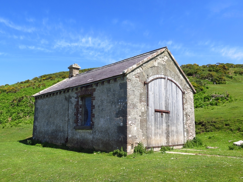
The Board of Trade decided in 1876 to establish a lifesaving apparatus station at Rhossili (with a cart and rockets, lines, breeches-buoys, etc.), for attending shipwrecks on the coast. There was initially much difficulty in getting volunteers to man the apparatus because of the strong tradition, within recent living memory, of wrecking activity and hostility to the Coastguard service. The first wreck attended by the Rocket Crew with the new apparatus was on the shore near the Old Rectory in 1879. The Rocket Crew was later renamed the Rhossili Lifesaving Apparatus Company.
The cart shed was completed by 1878 when it appears on the OS map, marked 'Rocket House'. The shed appears to have been re-roofed at some time with inferior workmanship.
A building about 5 by 8 metres in plan. Local limestone walls about 0.45 m in thickness, rendered on all sides except to the east, but with exposed quoins. Slate roof with tile ridge; projecting rafter-ends at eaves (for lost fascias); at the verges the sarking boarding projects and carries a course of bricks in cement to secure the slates. Small brick chimney at north gable end, with a concrete cap at cornice level. Rainwater gutters and pipes have been lost.
Dressed stone jambs and segmental arch to cart doorway in the south gable end: the stones pecked with chiselled margins. The shed doors are ledged, braced, battened, with cover strips over the batten joints, and turn on full length bolted iron strap hinges. Wicket door within the left door. Concrete tracks to the front of the shed for the cart to run out on.
Single window to east and single window to west: brick quoins and cambered arches, sandstone sills. Remnants only of window frames and security bars.
Included on the list for its historic interest as a well-preserved relic of the late C19 coastguard service.
External links are from the relevant listing authority and, where applicable, Wikidata. Wikidata IDs may be related buildings as well as this specific building. If you want to add or update a link, you will need to do so by editing the Wikidata entry.


Other nearby listed buildings
