Approximate Location Map
Large Map »
Latitude: 51.6007 / 51°36'2"N
Longitude: -4.2217 / 4°13'18"W
OS Eastings: 246224
OS Northings: 191433
OS Grid: SS462914
Mapcode National: GBR GR.K4GL
Mapcode Global: VH3MW.S107
Plus Code: 9C3QJQ2H+78
Entry Name: Bethesda Presbyterian Chapel
Listing Date: 3 March 2000
Last Amended: 3 March 2000
Grade: II
Source: Cadw
Source ID: 22875
Building Class: Religious, Ritual and Funerary
Also known as: Bethesda Calvinistic Methodist Chapel
ID on this website: 300022875
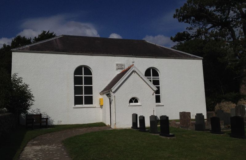
Location: Prominently sited on the north side of the Green at Burry Green.
County: Swansea
Town: Swansea
Community: Llangennith, Llanmadoc and Cheriton (Llangynydd, Llanmadog a Cheriton)
Community: Llangennith, Llanmadoc and Cheriton
Locality: Burry Green
Traditional County: Glamorgan
Tagged with: Chapel
Lady Diana Barham, whose family were in the same Calvinistic circle as George Whitefield and Selena, Lady Huntington, came to Gower in 1813 and perceived the need for missionary activity here. She discovered a Calvinistic society (active from at least 1809) about to erect a small meeting house at Burry Green, and offered to pay for the erection of a larger chapel with manse. The chapel was opened in 1814. The earliest ministers at Burry Green were of Lady Huntington's Connexion, sent in rotation. Lady Barham requested the Calvinistic Methodist Association to send a permanent minister to serve in Gower. In 1821 there was a break between Lady Barham and the Calvinistic Methodist Association, as she changed allegiance to the Independents. After her death in 1823, her son, Lord Barham, gave his patronage to William Griffiths (who had been dismissed by Lady Barham, but ordained in 1824) as Calvinistic Methodist minister at Burry Green. Burry Green was thereafter the 'central home' of Calvinistic Methodism in Gower, where the Sacraments were administered and new members received.
William Griffiths remained minister here until his death in 1861. In 1855 he persuaded Lord Barham (who had contemplated giving Bethesda to the Anglican church, as a chapel-of-ease) to give it to the Calvinistic Methodists. Griffiths came to be called 'the father of Calvinistic Methodism in Gower' and 'the Apostle of Gower'.
The manse and the enclosing wall of the forecourt were all built at the same time as the chapel. It is thought that the original layout of the chapel included a table and Communion rails in the position of the present pulpit, with a pulpit then situated against the south wall near to the east corner. The bow-fronted balcony is plainly original, and relates to a pulpit against the south wall.
The little annexe or private pew at the north-east corner of the chapel, known as Lady Barham's room, was probably built in 1814, when Lady Barham came to live at Fairy Hill nearby. This room had a door the top half of which could be opened to enable her to take part in the service. It is said she would close it if the sermon was too long. The bow-fronted gallery is original, but the west gallery may be an early addition. Towards the end of the C19 the interior layout was altered, with a new pulpit and set fawr. The space beneath the west gallery has been screened off as a vestry. The front porch was probably a late addition; a C19 drawing displayed in the vestry shows the porch with a flat roof.
A chapel standing within a stone-walled and railed enclosure together with its manse. The manse and the link section joining it to the chapel have been considerably modernised, but the chapel retains its symmetrical elevation to the south, facing Burry Green, albeit rendered; two-window front elevation with later porch; slate roof hipped at each end. The name is displayed on a stone above the porch. At the north east corner is a small annexe known as Lady Barham's room. The east and west end-elevations of the chapel are each also of two windows. Original multi-pane windows with interlacing glazing bars survive in the end elevation towards the manse, the other windows all have late C19 replaced timber windows. The rear elevation is blank apart from the gallery door and exterior stairs.
The finest feature of the interior is the bow-fronted original gallery supported on columns, built out from the north wall. Moulded handrail on inch-square balusters, above broad panels with a base moulding. Plain continuous beam carried on three surviving Tuscan columns.
The interior has been altered. Two blocks of late C19 pine pews face the pulpit position to the east. Boarded dado. Slightly raised set fawr in pine with canted corners. Pulpit with panelled back panelling including a brass memorial plaque. At the west of the room is a secondary gallery and beneath that a later vestry partition the panels of which can be opened.
Listed notwithstanding alterations as a good early C19 chapel retaining its original gallery, and as an important early centre of Calvinistic Methodist evangelism and the influence of Lady Huntington's Connexion in Gower.
External links are from the relevant listing authority and, where applicable, Wikidata. Wikidata IDs may be related buildings as well as this specific building. If you want to add or update a link, you will need to do so by editing the Wikidata entry.


Other nearby listed buildings
