Approximate Location Map
Large Map »
Latitude: 51.5484 / 51°32'54"N
Longitude: -3.2731 / 3°16'23"W
OS Eastings: 311818
OS Northings: 184051
OS Grid: ST118840
Mapcode National: GBR HT.FMDL
Mapcode Global: VH6DZ.6BZT
Plus Code: 9C3RGPXG+9Q
Entry Name: Railway Viaduct over River Taff (partly in Llantwit Fardre community)
Listing Date: 28 April 2000
Last Amended: 28 April 2000
Grade: II
Source: Cadw
Source ID: 23233
Building Class: Transport
Also known as: Railway Viaduct over River Taff (partly in Llantwit Fardre community)
ID on this website: 300023233
Location: Immediately N of the recreation ground adjoining Fynnon Taff Primary School.
County: Rhondda Cynon Taff
Town: Pontypridd
Community: Taffs Well (Ffynnon Taf)
Community: Taffs Well
Built-Up Area: Taff's Well
Traditional County: Glamorgan
Tagged with: Viaduct Railway viaduct
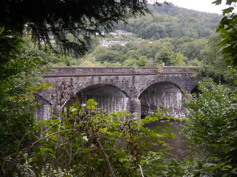
The Taff Vale Railway was an independent railway promoted by the industrialists of S Wales to avoid congestion on the Glamorganshire Canal. The company was incorporated in 1836, and the line was opened from Cardiff to Abercynon in 1840 and extended to Merthyr in 1841. It was single track with passing places, but doubling began in 1845 and was complete by 1861. A great increase in traffic movements led, in 1885, to a quadrupling of the line as far as Pontypridd. The viaduct belongs to this campaign, as it is shown with 4 tracks on the 2nd edition Ordnance Survey of 1900.
Five-arch viaduct of coursed rock-faced stone. The bridge is at an angle to the river and the arches are skewed. The W arch spans a riverside path, while the remaining arches span the river. Wide segmental arches of voussoirs and tall projecting keystones with margin drafting. White brick to soffits of arches. Rounded cutwaters to N side only, with domed caps. Moulded stone string course with margin drafting, and saddleback coping to parapets in a similar style. Piers with caps to abutments.
Listed as an unaltered railway viaduct of the later C19, retaining its character, and reflecting the massive expansion in railway traffic, largely caused by coal exporting.
External links are from the relevant listing authority and, where applicable, Wikidata. Wikidata IDs may be related buildings as well as this specific building. If you want to add or update a link, you will need to do so by editing the Wikidata entry.


Other nearby listed buildings
