Approximate Location Map
Large Map »
Latitude: 51.5685 / 51°34'6"N
Longitude: -3.7284 / 3°43'42"W
OS Eastings: 280304
OS Northings: 186925
OS Grid: SS803869
Mapcode National: GBR H6.DDWJ
Mapcode Global: VH5H2.BT9Z
Plus Code: 9C3RH79C+9J
Entry Name: Monastic Baths
Listing Date: 25 April 2000
Last Amended: 25 April 2000
Grade: II*
Source: Cadw
Source ID: 23274
Building Class: Religious, Ritual and Funerary
Also known as: Margam Medieval Bath House
Ffynnon Gyffyr
ID on this website: 300023274
Location: Located on the W bank of the Afon Cwm Bach, on the E side of a track. To the N, the track bends round sharply to the E, over the river, and on to Cwm Maelwg Farm.
County: Neath Port Talbot
Town: Port Talbot
Community: Margam
Community: Margam
Locality: Cwm Bach
Traditional County: Glamorgan
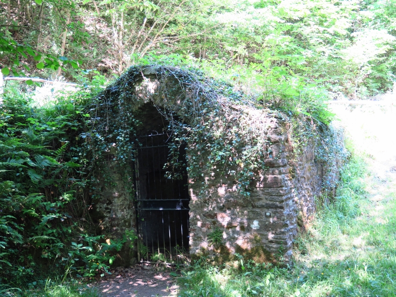
A complete medieval bath house, probably C14-15. Though probably connected with Margam Abbey, it is most likely to have been a baptistry for the local population who worshiped at the nearby Hen Eglwys. However, it is also known as Fynnon Gyffyr (medicinal spring) and it may have been used in earlier times for healing.
Rectangular structure of rubble stone with keeled vaulted roof covered in vegetation. The N and W sides are built into the bank, while the S and E sides are free-standing. The ground slopes down sharply to the E towards the Afon Cwm Bach which finally leads into the abbey fishpond (now lake). Shallow pointed arched entrance to S end. Head of narrow raked stones and a triangular keystone, resting on impost blocks. Sockets at spring level, probably for a door or gate. One small lancet window to E side.
The E window has wide splayed reveals and a stone sill. Wide recess in W wall and bench to N end. L-shaped pool surrounded by paving and with steps leading down from the S end. Water inlet channel to the N.
Listed grade II* as an unusual and complete survival of a medieval baptistry and holy well.
External links are from the relevant listing authority and, where applicable, Wikidata. Wikidata IDs may be related buildings as well as this specific building. If you want to add or update a link, you will need to do so by editing the Wikidata entry.


Other nearby listed buildings
