Approximate Location Map
Large Map »
Latitude: 53.2314 / 53°13'53"N
Longitude: -4.1108 / 4°6'38"W
OS Eastings: 259206
OS Northings: 372565
OS Grid: SH592725
Mapcode National: GBR 5Q.0HWM
Mapcode Global: WH547.T1PK
Plus Code: 9C5Q6VJQ+HM
Entry Name: Pont Penrhyn (partly in Bangor community)
Listing Date: 2 August 1988
Last Amended: 24 May 2000
Grade: II
Source: Cadw
Source ID: 23362
Building Class: Transport
ID on this website: 300023362
Location: Spanning the Afon Cegin just south of the present main approach to the docks at Porth Penrhyn, the road carried by the bridge leads to the Port Lodge entrance to Penrhyn Castle.
County: Gwynedd
Community: Llandygai (Llandygái)
Community: Llandygai
Locality: Porth Penrhyn
Built-Up Area: Bangor
Traditional County: Caernarfonshire
Tagged with: Bridge Road bridge
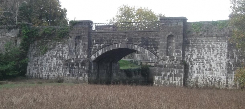
The original bridge was built by George Hay Dawkins-Pennant, probably to the designs of Benjamin Wyatt (architect to the Penrhyn Estate) in order that the horse tramway from the Penrhyn Quarry could pass directly on to the wharf at Porth Penrhyn. The 2 railway arches beneath the road were inserted in 1876 as part of the new narrow gauge railway line of 1' 10 3/4" (0.6m) running from the quarry through Tregarth, along the Afon Cegin valley to its terminus at Porth Penrhyn. The Penrhyn Railway continued to operate a passenger service for the quarrymen until 1951 and ceased work in 1962 at which time the rails were taken up. There was formerly a cast-iron bridge immediately to the north of Pont Penrhyn. This was built in 1852 to carry the branch line linking the wharf with the Chester-Holyhead railway line opened in 1849 but has since been replaced by the present road bridge in the same position. The Afon Cegin here marks the boundary between Llandygai and Bangor communities.
River and railway bridge spanning both the Afon Cegin and former railway tracks. Regularly coursed rubblestone with massive chamfered slate-stone coping to main structure (each coping stone in 2 pieces to section over river and in single pieces to parapet over railway) and with stone-on-edge coping to abutments. Single segmental arch over river with voussoirs, keystone and arch-ring terminated by rectangular piers with round-headed niches; iron plate to arch has superscription "GHDP/1820" and balustrade above is of decorative ironwork. Beneath the roadway at the eastern end of the bridge are the 2 segmental arches over the former railway, eastern infilled, both with brick soffits and iron gate hinges for original gates.
Included as a distinctive and well-detailed early C19 bridge forming an integral feature of the remarkable late C18 and C19 industrial port complex at Porth Penrhyn. The bridge has strong group value with the other structures here, in particular Port House and Hen Swyddfa'r Porthladd (Old Port Office).
External links are from the relevant listing authority and, where applicable, Wikidata. Wikidata IDs may be related buildings as well as this specific building. If you want to add or update a link, you will need to do so by editing the Wikidata entry.


Other nearby listed buildings
