Approximate Location Map
Large Map »
Latitude: 51.6294 / 51°37'46"N
Longitude: -4.062 / 4°3'43"W
OS Eastings: 257377
OS Northings: 194306
OS Grid: SS573943
Mapcode National: GBR GV.WBNB
Mapcode Global: VH4K7.J9YQ
Plus Code: 9C3QJWHQ+Q6
Entry Name: Stable and cowshed, Crwys Farm
Listing Date: 5 June 2000
Last Amended: 5 June 2000
Grade: II
Source: Cadw
Source ID: 23483
Building Class: Agriculture and Subsistence
ID on this website: 300023483
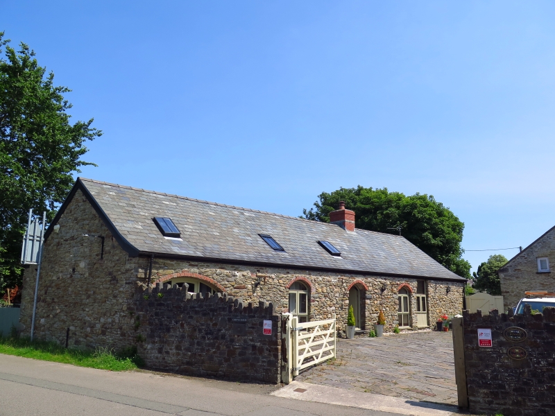
Location: To the north of Crwys farmhouse, its gable facing Gowerton Road; it stands to the NW of a small farmyard adjacent to the farmhouse.
County: Swansea
Town: Swansea
Community: Three Crosses (Y Crwys)
Community: Llanrhidian Higher
Locality: Three Crosses
Built-Up Area: Three Crosses
Traditional County: Glamorgan
Tagged with: Stable
Crwys farmhouse dates from the late C18, and is shown on an estate map of 1779. The farm building range to the north appears to be a C19 addition, shown on the 1878 map. The range is principally a cattle shed, with a part at left having been a potato store and part at right a stable. An additional part at rear was a chaff room.
Single-storey farm range of local rubble sandstone facing Crwys farmyard, with masonry in a mixture of stones from two sources, roughly coursed. The range has a small extension at rear part of which is of two storeys. The roofs have all been replaced in sheeting. A roadside wall, with a sloping top, rubble coping and gateway, links this to the range to the other side of the yard. Additional modern shed for milking equipment at the SE end.
The front elevation has four brick-arched openings and one additional stable doorway for which the wallplate is the head. The archway at left is walled up in brickwork. The elevation to the street has one small high-level opening.
Part of the buildings of a small mixed farmstead, listed for group value with Crwys farmhouse.
External links are from the relevant listing authority and, where applicable, Wikidata. Wikidata IDs may be related buildings as well as this specific building. If you want to add or update a link, you will need to do so by editing the Wikidata entry.


Other nearby listed buildings
