Approximate Location Map
Large Map »
Latitude: 52.6215 / 52°37'17"N
Longitude: -3.995 / 3°59'42"W
OS Eastings: 265046
OS Northings: 304504
OS Grid: SH650045
Mapcode National: GBR 8W.7WJC
Mapcode Global: WH576.LCTN
Plus Code: 9C4RJ2C3+HX
Entry Name: Dolgoch Viaduct
Listing Date: 15 August 2000
Last Amended: 19 September 2000
Grade: II
Source: Cadw
Source ID: 23900
Building Class: Transport
ID on this website: 300023900
Location: The viaduct carries the Tal-y-llyn narrow gauge railway over the Nant Dol-goch, reached by pathway from the B4405 past Dolgoch Farm.
County: Gwynedd
Community: Bryn-crug
Community: Bryn-Crug
Locality: Bryn Crug
Traditional County: Merionethshire
Tagged with: Viaduct Railway viaduct
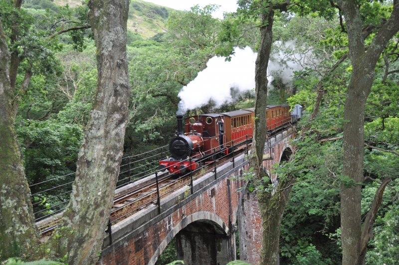
The Talyllyn Railway was incorporated by the Talyllyn Railway Act, 28 & 29 Victoria cap cccxv of 5 July 1865. Its primary purpose was to carry slate products from the productive Bryn Eglwys quarry to the Aberystwyth & Welsh Coast Railway at Tywyn. The line was surveyed and engineered by James Swinton Spooner. A gauge of 2ft 3in (0.686m) was adopted. The greatest single obstacle was the gorge of Nant Dolgoch, which was bridged by a viaduct to maintain an even gradient. The railway opened to goods and mineral traffic in July 1866 and passengers in December 1866. Traffic declined from the late 1930s onwards but the railway continued in operation for passengers and goods until 1950, despite the closure of the slate quarries in 1947. Closure and dismantling were held off due to the owner's insistence that the railway should continue to operate during his lifetime. The railway became notable as the first to be rescued from closure by voluntary effort.
The viaduct is built of red brick with flush margin-drafted stone dressings. Three segmental spans carried on two tall slightly tapered piers each 10.3m high above a chamfered base, carrying the track 15.4m (50ft 6in) above the water. The centre arch spans 9.2m and the overall width is 2.8m. There is a triangular refuge cantilevered off at mid span, and it has 4 simple horizontal railings threaded through iron stanchions, set on the low parapets. Stone chamfered revetments. The bridge was rebuilt above the arch tops in 1969-1970 and steel bars with square restraining plates set below the parapets.
Included as a fine and simply designed railway structure for a narrow gauge railway, one of the few elements along the line to be in its original condition.
External links are from the relevant listing authority and, where applicable, Wikidata. Wikidata IDs may be related buildings as well as this specific building. If you want to add or update a link, you will need to do so by editing the Wikidata entry.


Other nearby listed buildings
