Approximate Location Map
Large Map »
Latitude: 51.8947 / 51°53'41"N
Longitude: -4.9065 / 4°54'23"W
OS Eastings: 200107
OS Northings: 225792
OS Grid: SN001257
Mapcode National: GBR CN.QX6N
Mapcode Global: VH1R1.WMZV
Plus Code: 9C3QV3VV+V9
Entry Name: Church of St Mary
Listing Date: 21 November 2000
Last Amended: 21 November 2000
Grade: II
Source: Cadw
Source ID: 24393
Building Class: Religious, Ritual and Funerary
ID on this website: 300024393
Location: Situated in large churchyard in centre of Ambleston village.
County: Pembrokeshire
Town: Haverfordwest
Community: Ambleston (Treamlod)
Community: Ambleston
Traditional County: Pembrokeshire
Tagged with: Church building
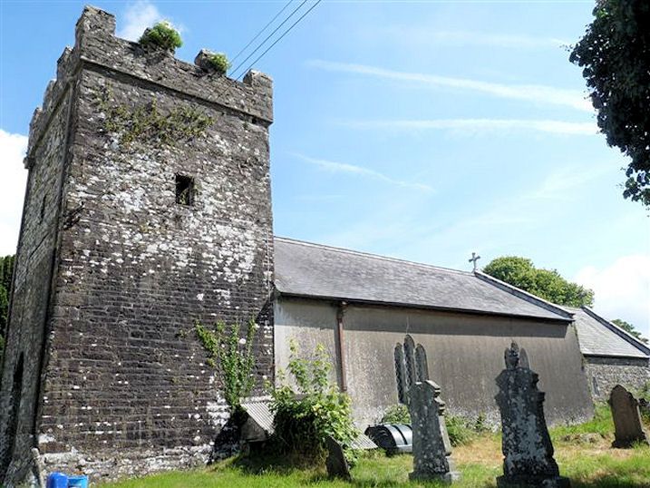
Anglican parish church, medieval origins. Tower partly rebuilt in 1779 according to the datestone, but the battered plinth, winding stair and apparent stone vault within suggest that the lower half at least is medieval, in an unusual conglomerate stone. The nave is much rebuilt, the two blocked N windows look early C19 rather than medieval. They may relate to an estimate for repairs in 1825 by William Owen of Haverfordwest and James Hughes of Narberth, including roofing £16/17/6d(£16.88), tiling £7/10/0d(£7.50), three windows and shutters £6. The main restoration was by H.J.P. Thomas of Haverfordwest in 1906: new seating, pulpit, vestry screen, doors, new roofs and heating chamber are in the specification, for £450. The medieval font was returned to the church in 1913, having been a cheese-press on a local farm.
Church, rubble stone with slate roofs, coped gables and cross finials. W tower, nave and chancel. W tower is of squared conglomerate stones and laid in courses, with battered plinth and plain tower, the upper part with more mixed stone. Tower may have been shortened. NE stair turret. Corbelled embattled parapets, stair tower parapet with stone 'JP WT 1779'. N bell opening is square with stone voussoirs and timber louvres, perhaps C18, tiny W and S bell openings. W door has tall pointed arch, possibly C19, breaking into base of a blocked pointed window, both with stone voussoirs. Double early C20 board doors with Y-tracery overlight. Nave and chancel have brick courses under eaves. Nave has C19 or early C20 windows of 3 stepped lights, 2 to nave each side, N wall has traces of two blocked windows, S wall is rendered. Chancel has N side 2-light window set to right, with cusping, and stone voussoirs over, S side single C19 cusped light and E end small 3-light window with stepped lancets and grey stone voussoirs. Square medieval font on round shaft.
Mostly early C20, plastered walls with open roofs. Tower appears to have a stone pointed vault, plastered over, and there is a conglomerate stone 4-centred arched doorway on N to stone winding stairs. A stone bowl on the floor with 4 lugs may be a stoup. W wall to church appears thinner than other tower walls. Nave has 5 arch-braced collar trusses on corbels, plastered walls and low plastered pointed chancel arch. Square medieval font on round shaft, C12 or C13. Early C20 oak pews and timber Gothic pulpit. Chancel has 5-bay scissor-truss roof. Later C20 chancel fittings in pale oak including stalls, reading desk, kneelers, rails and panelling. East window of 1965 by Celtic Studios, the Supper at Emmaus. Nave N wall plain plaque of 1827 to Admiral Thomas Tucker (d 1766).
Included as a parish church with medieval origins including vaulted W tower.
External links are from the relevant listing authority and, where applicable, Wikidata. Wikidata IDs may be related buildings as well as this specific building. If you want to add or update a link, you will need to do so by editing the Wikidata entry.


Other nearby listed buildings
