Approximate Location Map
Large Map »
Latitude: 51.7578 / 51°45'27"N
Longitude: -2.6814 / 2°40'52"W
OS Eastings: 353065
OS Northings: 206782
OS Grid: SO530067
Mapcode National: GBR JM.0D6Z
Mapcode Global: VH877.G2TV
Plus Code: 9C3VQ859+4C
Entry Name: Clearwater House
Listing Date: 28 February 2001
Last Amended: 28 February 2001
Grade: II
Source: Cadw
Source ID: 24943
Building Class: Domestic
ID on this website: 300024943
Location: On the north side of the Whitebrook valley road and about 450m west of the Church of the Holy Trinity.
County: Monmouthshire
Town: Monmouth
Community: Trellech United (Tryleg Unedig)
Community: Trellech United
Locality: Whitebrook
Traditional County: Monmouthshire
Tagged with: House
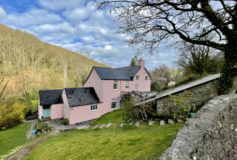
This house dates probably from the late C18 and was built as the manager's house of the adjacent Clearwater Mill (now ruins). This mill was built c1760, it was the first paper mill in the Whitebrook valley and was worked for over a hundred years. It was clearly a prosperous concern when this house was built but despite extensive improvements, with the introduction of steam power and continuous paper making in the 1860s, the mill had closed by 1875. The most significanrt alteration to the house since is the introduction of the two large tripartite windows in c1975.
The house is wholly rendered, probably over local rubble stone and has a Welsh slate roof. It is a central entry double depth plan house with a service wing at the rear. Two storeys and garret to the front range and two storeys only to the service wing. The main elevation is of three bays with a central 6-panel door with a guilloche mould architrave, and a Regency timber porch with tented lead roof. This is flanked on the left by a late C20 tripartite sash window with 6 over 6 panes flanked by 2 over 2, and on the right by a 6 over 6 pane sash without horns. The upper floor has another tripartite window to the left and two other 6 over 6 sashes to the centre and right, these have horns. The right hand gable has a window to each of the rear rooms. The left hand gable has two windows 2 2 casements on the attic floor. Projecting late C20 conservatory on the ground floor. Rear wing two storeys only, two windows, one a 6 over 6 sash, other windows later.
The entrance door leads to a straight flight stair with stick balusters, this rises to the attic. Main reception rooms flank this to the front, these retain some Georgian features. The hall goes through to the service wing with stone paved floor and modernised kitchen. Upper floors not seen at time of resurvey.
Included as a late C18 house having an historical connection with the Whitebrook valley paper industry.
External links are from the relevant listing authority and, where applicable, Wikidata. Wikidata IDs may be related buildings as well as this specific building. If you want to add or update a link, you will need to do so by editing the Wikidata entry.


Other nearby listed buildings
