Approximate Location Map
Large Map »
Latitude: 51.878 / 51°52'40"N
Longitude: -2.7885 / 2°47'18"W
OS Eastings: 345820
OS Northings: 220227
OS Grid: SO458202
Mapcode National: GBR FH.RT33
Mapcode Global: VH794.M265
Plus Code: 9C3VV6H6+5J
Entry Name: Skenfrith Bridge
Listing Date: 19 March 2001
Last Amended: 19 March 2001
Grade: II
Source: Cadw
Source ID: 25047
Building Class: Transport
ID on this website: 300025047
Location: Crossing the River Monnow approximately 100m E of Skenfrith Castle.
County: Monmouthshire
Town: Monmouth
Community: Llangattock-Vibon-Avel (Llangatwg Feibion Afel)
Community: Skenfrith
Traditional County: Monmouthshire
Tagged with: Bridge
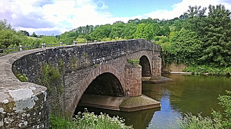
Rebuilt in 1824 by the County of Monmouth.
A 3-span stone-built public road bridge over the River Monnow. Built of coursed rubble with dressed voussoirs and parapet copings. Three segmental arches with plain dressed voussoirs, the central arch slightly higher than the others, with triangular cutwaters to both sides, a plain string-course to each side, and parapets with slightly convex copings. The two piers in the centre are now protected by shallow hexagonal concrete plinths. In the centre of the inner side of the south parapet is a wide rectangular panel bearing the inscription "This Bridge was Rebuilt at the Expense of the County of Monmouth in the Fifth year of The Reign of GEORGE THE FOURTH, And in the year of Our LORD 1824". (This is slightly eroded but still legible.) The bridge groups well Skenfrith Mill (q.v.) and Skenfrith Castle (q.v.).
The eastern half of the structure is in the County of Herefordshire, England.
Included as a well-designed Georgian bridge, and for its group value with Skenfrith Mill and Skenfrith Castle.
External links are from the relevant listing authority and, where applicable, Wikidata. Wikidata IDs may be related buildings as well as this specific building. If you want to add or update a link, you will need to do so by editing the Wikidata entry.


Other nearby listed buildings
