History in Structure

Entrance piers and flanking walls at Pantasaph Friary

A Grade II Listed Building in Whitford, Flintshire

More Photos »
Approximate Location Map
Large Map »

Coordinates

Latitude: 53.2742 / 53°16'27"N

Longitude: -3.2607 / 3°15'38"W

OS Eastings: 316027

OS Northings: 375991

OS Grid: SJ160759

Mapcode National: GBR 5ZNK.VZ

Mapcode Global: WH76J.WYGS

Plus Code: 9C5R7PFQ+MP

Entry Name: Entrance piers and flanking walls at Pantasaph Friary

Listing Date: 25 May 2001

Last Amended: 25 May 2001

Grade: II

Source: Cadw

Source ID: 25252

Building Class: Religious, Ritual and Funerary

ID on this website: 300025252

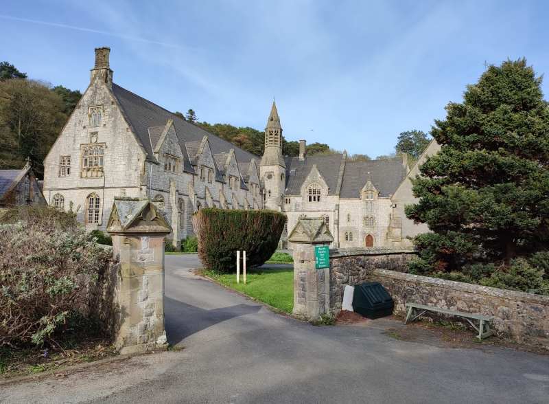
Location: Set back from the road and bounding an area of tarmac and gardens in front of the friary. The entrance is to the SW.

County: Flintshire

Town: Holywell

Community: Whitford (Chwitffordd)

Community: Whitford

Locality: Pantasaph

Traditional County: Flintshire

Tagged with: Wall

Find accommodation in
Holywell

History

Probably contemporary with the friary buildings, which were constructed from 1858 to 1865.

Exterior

A pair of square-section stone piers with dressed stone quoins and ornate capstones. These have 4-sided gablets with mouldings, their faces bearing stylised blind trefoils. The flanking rubble stone walls have 2 tiers of stone tile copings. The R wall runs E to the SW angle of St David's Church, whilst the L wall runs NW and terminates close to the SE angle of the guest-house with an end pier in the same style.

Reasons for Listing

Listed for group value with Pantasaph Friary.

External Links

External links are from the relevant listing authority and, where applicable, Wikidata. Wikidata IDs may be related buildings as well as this specific building. If you want to add or update a link, you will need to do so by editing the Wikidata entry.

Recommended Books

Other nearby listed buildings

  • II* Guest House including linking range at Pantasaph Friary
    Set back from the road and approached by driveways. The linking range, which includes the main entrance, joins the guest house with the friary, which is to the R.
  • II* The Roman Catholic Church of St David
    Adjoining the R side of Pantasaph Friary and in the grounds.
  • II* Franciscan Friary
    Set back from the road in grounds and approached by driveways. The Church of St David adjoins to the R. A linking range to the L joins the friary with the guest house and includes the entrance to th
  • II Archway to the Way of the Cross at Pantasaph Friary
    Set back to the NW of the friary buildings, and forming the access to the Way of the Cross and The Grotto.
  • II Chapel of the Sepulchre, including walls flanking entrance
    Located to the N of Pantasaph Friary and reached by a path which zig-zags up the hill following the stations of the cross. Located close to the summit, in front of the Calvary, and built into the slo
  • II West Gate
    On the W edge of the grounds of Pantasaph Friary and facing S. The lane on its W side runs N to Carmel.
  • II Telephone Call-box
    At the roadside to the SE of the Fielding Arms Public House on the NW edge of Pantasaph.
  • II Limekiln
    In a prominent position fronting the road between Carmel and Gorsedd. On the S side of the road and at a junction with a lane running N.

BritishListedBuildings.co.uk is an independent online resource and is not associated with any government department. All government data published here is used under licence. Please do not contact BritishListedBuildings.co.uk for any queries related to any individual listed building, planning permission related to listed buildings or the listing process itself.

British Listed Buildings is a Good Stuff website.