Approximate Location Map
Large Map »
Latitude: 51.9933 / 51°59'35"N
Longitude: -4.9772 / 4°58'37"W
OS Eastings: 195695
OS Northings: 236947
OS Grid: SM956369
Mapcode National: GBR CK.JQ3B
Mapcode Global: VH1QM.P538
Plus Code: 9C3QX2VF+84
Entry Name: 16, High Street, Fishguard, Fishguard, SA65 9AR
Listing Date: 24 November 1978
Last Amended: 7 January 2002
Grade: II
Source: Cadw
Source ID: 26048
Building Class: Domestic
ID on this website: 300026048
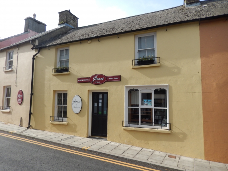
Location: Situated on the street line between Nos 14 and 18, a pair with No 14.
County: Pembrokeshire
Town: Fishguard
Community: Fishguard and Goodwick (Abergwaun ac Wdig)
Community: Fishguard and Goodwick
Locality: Fishguard
Built-Up Area: Fishguard
Traditional County: Pembrokeshire
Tagged with: Building
Late C18 to mid C19 terraced house. Building shown on this site on tithe map of 1844 and on 1808 Kensington Estate map. The premises was in commercial use in 1897 according to a photograph showing attached sign-boards, but may have reverted to domestic use by the 1930s. Built as a pair with No 14, and with similar later C19 shop window.
Terraced house, unpainted stucco cladding lined as ashlar, with cement grouted roof with one roof light, and shared, rendered stack at right, left stack rebuilt with No 18. Two-storey double-fronted elevation, upper floor with 2-4-pane sash windows with heads under eaves. Ground floor with 4-pane sash window to left and C19 shop window of 3 transomed lights with ogee-shaped heads to upper lights, the centre one opening. Central doorway with C20 door.
Included as one of the earlier houses of the High Street, as indicated by the relatively lower proportions, for group value with the matching No 14 with similar C19 shop-window, and for grouted roof, one of the last in the town.
External links are from the relevant listing authority and, where applicable, Wikidata. Wikidata IDs may be related buildings as well as this specific building. If you want to add or update a link, you will need to do so by editing the Wikidata entry.


Other nearby listed buildings
