Approximate Location Map
Large Map »
Latitude: 53.2859 / 53°17'9"N
Longitude: -3.4019 / 3°24'6"W
OS Eastings: 306635
OS Northings: 377463
OS Grid: SJ066774
Mapcode National: GBR 4ZPF.9T
Mapcode Global: WH76G.QN7T
Plus Code: 9C5R7HPX+96
Entry Name: Hooded tomb in the churchyard of Saints Mael and Sulien
Listing Date: 11 January 2002
Last Amended: 11 January 2002
Grade: II*
Source: Cadw
Source ID: 26087
Building Class: Religious, Ritual and Funerary
ID on this website: 300026087
Location: Adjacent to the south wall of the St Mael & St Sulien's church.
County: Denbighshire
Community: Cwm
Community: Cwm
Locality: Cwm Village
Traditional County: Flintshire
Tagged with: Tomb
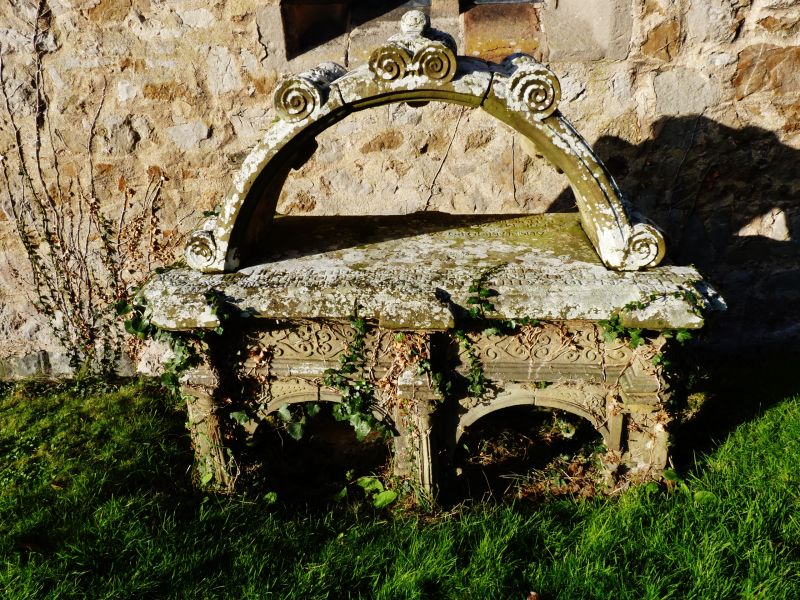
The inscription on the ledger records that this is the tomb of Grace Griffith, of ... in the County of Denbigh, d. 1642. The 'hooded' form of the tomb (surmounted by an arch) is a local traditional type, other local examples being found in the graveyards of Dyserth and Trelawnyd. Lewis in 1833 refers to this 'ancient tombstone, on which is a bow sculptured in stone'.
Another inscription faces the church wall so that it cannot easily be read; this suggests the tomb is no longer in situ.
This tomb has been described by Hubbard as the most elaborate of the Welsh hooded tombs. The base consists of one by two arches, with fluted pilasters at the corners and between the side arches. Above this is a frieze carved in relief with formalised foliage, and a ledger moulded at the edge and shaped to follow the projections of the pilasters. Above is a hood in the form of a freestanding arch, with carved rolls and trefoil headed sunk panels on the exterior; on its inside face is an angel at one side and a skull between two heraldic shields at the other.
On the ledger is the inscription 'Loe my sad pledge one last adieu is here recorded to thy view. Reader behold my losse so deare. Spare thy censure, shed a teare'.
Listed at grade II* as a particularly fine example of this unusual type of monument.
External links are from the relevant listing authority and, where applicable, Wikidata. Wikidata IDs may be related buildings as well as this specific building. If you want to add or update a link, you will need to do so by editing the Wikidata entry.


Other nearby listed buildings
