Approximate Location Map
Large Map »
Latitude: 51.6737 / 51°40'25"N
Longitude: -3.9934 / 3°59'36"W
OS Eastings: 262260
OS Northings: 199094
OS Grid: SS622990
Mapcode National: GBR GX.7QR3
Mapcode Global: VH4K2.Q6Q9
Plus Code: 9C3RM2F4+FM
Entry Name: The Equatorial Observatory, Penllergare
Listing Date: 30 April 2002
Last Amended: 6 February 2023
Grade: II*
Source: Cadw
Source ID: 26500
Building Class: Recreational
ID on this website: 300026500
Location: Situated some 60m NW of the Neath Port Talbot Borough Council offices in Penbwl Wood.
County: Swansea
Town: Swansea
Community: Penllergaer (Penlle'r-gaer)
Community: Penllergaer
Locality: Penbwl Wood
Traditional County: Glamorgan
Tagged with: Astronomical observatory
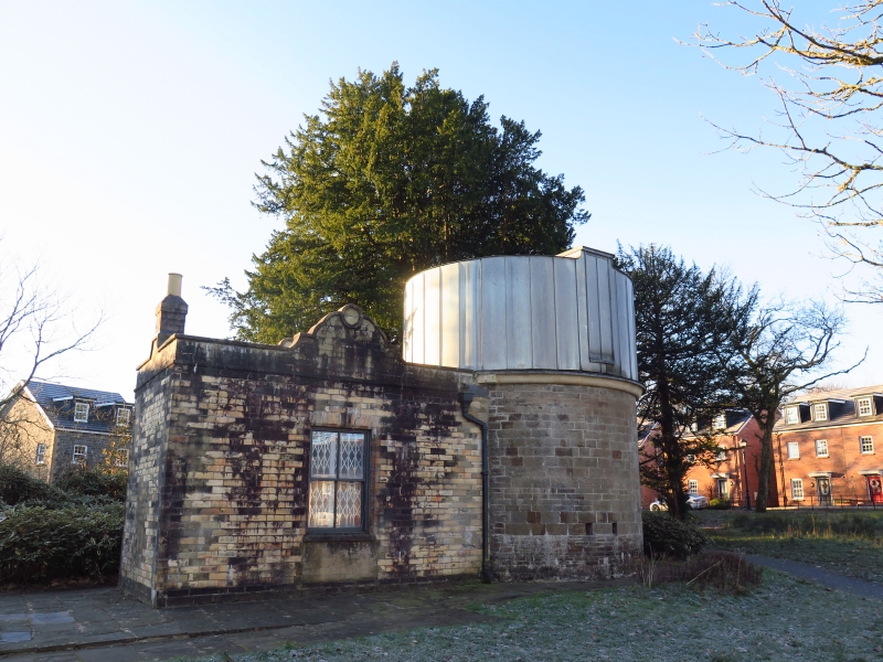
Observatory and laboratory built to house a telescope for John Dillwyn Llewelyn of Penllergare (1810-1882). He was interested in many areas of science including botany, boats driven by electric motors, astronomy and photography, and in 1855 he took one of the earliest photographs of the moon from the observatory.
Foundation stone laid 7 July 1851. The hollow blocks of which the laboratory was built were exhibited at the Great Exhibition of 1851. Renovated 1981 when the Lliw Valley Borough Council offices were built on the site of the mansion which was demolished in 1961.
Observatory and laboratory, the observatory a cylindrical tower of tolled squared stone with C20 metal-clad cylinder above, the laboratory a single-storey neo-Jacobean structure in yellow patent blocks, larger than conventional bricks. Observatory is windowless cylinder with some small square recess close to foot of the wall and an ogee cornice, eroded and patched in cement. The C20 top part has cylinder of metal sheets. The laboratory is a single room with slate roof behind parapet. Stone plinth, terracotta-block walls, the parapet with centre shaped neo-Jacobean gables rebuilt in imitation blocks in 1981. One window to N with C20 cross-window, possibly in former door opening. Surround is chamfered with terracotta block voussoirs. S side has similar window to right and door to centre, both with similar chamfered surrounds and voussoirs. C20 door and window.
Interior of observatory inaccessible, laboratory is single room with terracotta block walls and fireplace on right end wall.
Special historic and architectural interest as an extremely rare example of a mid C19 private observatory; the only other example in Wales is the partly ruinous observatory at Hakin, Milford Haven.
External links are from the relevant listing authority and, where applicable, Wikidata. Wikidata IDs may be related buildings as well as this specific building. If you want to add or update a link, you will need to do so by editing the Wikidata entry.


Other nearby listed buildings
