Approximate Location Map
Large Map »
Latitude: 51.7717 / 51°46'18"N
Longitude: -4.3912 / 4°23'28"W
OS Eastings: 235110
OS Northings: 210816
OS Grid: SN351108
Mapcode National: GBR DB.ZKG7
Mapcode Global: VH3LT.TQXP
Plus Code: 9C3QQJC5+MG
Entry Name: Albion House, including forecourt railings
Listing Date: 5 November 2002
Last Amended: 5 November 2002
Grade: II
Source: Cadw
Source ID: 27069
Building Class: Domestic
ID on this website: 300027069
Location: Situated at the S side of the High Street, at W end of a terraced row, opposite The Brackens
County: Carmarthenshire
Town: Carmarthen
Community: Llansteffan
Community: Llansteffan
Built-Up Area: Llansteffan
Traditional County: Carmarthenshire
Tagged with: House
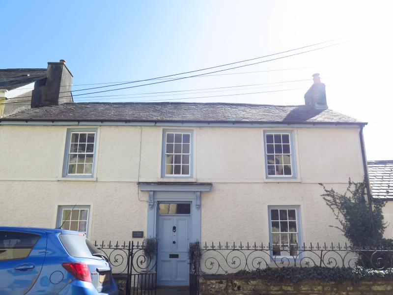
Village house formerly Albion inn, earlier C19, recorded as part of the Laques estate in 1855.
Early C19 end-terrace house, roughcast, 2 storeys, 3-window range. Slate eaves roof with end stacks, brown brick to W, taller rendered stack to E. Raised first floor sill band and narrow stucco surrounds to openings. Twelve-pane sashes with painted stone sills and painted reveals, hornless sashes to first floor. Central panelled timber door, half-glazed, within large C20 timber glazed porch with flat leaded roof over.
Forecourt wall is slate-capped rubble stone with square end-piers having stepped pyramidal stone caps. Wall carries typical locally-made wrought-iron rails with broad scrolls between two horizontal bars. Upper bar has spearheads with small flanking scrolls. Paired gates to centre with similar spearheads and scrolls, middle bar with outsize scrolls above and dog-bars below. Bottom margin.
Not inspected. Said to have broad central hall and central timber staircase with panelled timber internal doors.
Included as a good early C19 town house of late Georgian character.
External links are from the relevant listing authority and, where applicable, Wikidata. Wikidata IDs may be related buildings as well as this specific building. If you want to add or update a link, you will need to do so by editing the Wikidata entry.


Other nearby listed buildings
