History in Structure

Bridge at Red Wharf Bay

A Grade II Listed Building in Pentraeth, Isle of Anglesey

More Photos »
Approximate Location Map
Large Map »

Coordinates

Latitude: 53.2944 / 53°17'39"N

Longitude: -4.2011 / 4°12'4"W

OS Eastings: 253390

OS Northings: 379750

OS Grid: SH533797

Mapcode National: GBR JM0Z.SD6

Mapcode Global: WH53T.FGP9

Plus Code: 9C5Q7QVX+PG

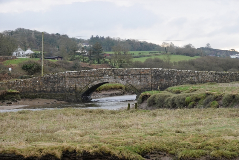
Entry Name: Bridge at Red Wharf Bay

Listing Date: 14 January 2003

Last Amended: 14 January 2003

Grade: II

Source: Cadw

Source ID: 80822

Building Class: Transport

ID on this website: 300080822

Location: Spanning a narrow tributary and carrying the coastal road along the southern edge of Red Wharf Bay; close to Pen-y-prys.

County: Isle of Anglesey

Community: Pentraeth

Community: Pentraeth

Locality: Red Wharf Bay

Tagged with: Bridge

Find accommodation in
Benllech

History

C18 or early C19 roadbridge.

Exterior

Roadbridge of rubble masonry with dressed stone voussoirs across a wide single arch; flanking piers are slightly advanced and there is a drip course below a shallow parapet wall.

Reasons for Listing

Included as a well preserved road bridge of C18 or early C19.

External Links

External links are from the relevant listing authority and, where applicable, Wikidata. Wikidata IDs may be related buildings as well as this specific building. If you want to add or update a link, you will need to do so by editing the Wikidata entry.

Recommended Books

Other nearby listed buildings

  • II Sandy Lane
    Set along the side of a narrow lane leading off the S side of Red Wharf Bay. No 1 is the left hand cottage in the range.
  • II Sandy Lane
    Set along the side of a narrow lane leading off the S side of Red Wharf Bay. No 2 is the right hand cottage in the range.
  • II Tower at Red Wharf Bay
    In an isolated location, within private grounds to the SE of Fron Goch; off a country road which leads down to Red Wharf Bay off the A5025. Located c1km NNE of the Church of St Mary at Pentraeth.
  • II The Ship Inn
    Set back from the NW coast of Red Wharf Bay.
  • II Beaumaris Lodge
    Set back from the W side of the B5109 on its E approach to Pentraeth.
  • II Gates and walled railings at Beaumaris Lodge
    Set back from the W side of the B5109 on its E approach to Pentraeth. The gates, walls and railings are along the road to S and E of the lodge.
  • II Hearse house at the Church of St Mary
    Set within the churchyard to NE of the Church of St Mary.
  • II Icehouse at Plas Gwyn
    Set back, within private grounds, between the A5025 and the B5109 SW of Pentraeth. The icehouse is said to lie to N of the house at Plas Gwyn.

BritishListedBuildings.co.uk is an independent online resource and is not associated with any government department. All government data published here is used under licence. Please do not contact BritishListedBuildings.co.uk for any queries related to any individual listed building, planning permission related to listed buildings or the listing process itself.

British Listed Buildings is a Good Stuff website.