Approximate Location Map
Large Map »
Latitude: 52.8241 / 52°49'26"N
Longitude: -3.4068 / 3°24'24"W
OS Eastings: 305304
OS Northings: 326104
OS Grid: SJ053261
Mapcode National: GBR 6N.V0Y8
Mapcode Global: WH78S.M8YS
Plus Code: 9C4RRHFV+J7
Entry Name: Church of St Cynog
Listing Date: 23 May 2003
Last Amended: 23 May 2003
Grade: II
Source: Cadw
Source ID: 81047
Building Class: Religious, Ritual and Funerary
ID on this website: 300081047
Location: At centre of the village of Llangynog at edge of the river floodplain, in a raised churchyard enclosed by a tall wall with steps and iron gates to the south. Tablet of 1791 in wall at north of churchy
County: Powys
Community: Llangynog (LLangynog)
Community: Llangynog
Locality: Llangynog village
Traditional County: Montgomeryshire
Tagged with: Church building
A single-chamber church of early origin, at the nucleus of a village which has preserved its early morphology. A church is first mentioned here in 1254 as ''''ecc''''a de Lankenant''''. The dedication commemorates a C5 martyr.
The church was rebuilt in 1791-2 in Georgian style, possibly on the old foundations, with round-headed doors and windows. It was again rebuilt or substantially altered by William Spaull of Oswestry in 1894. The inventory of 1911 described the old church as ''''entirely demolished'''' but the faculty for the work in 1894 implies less drastic work and it appears from the exterior trace of a priest''''s doorway into the chancel that some part of the pre-1894 masonry survived. All carpentry and joinery and all the architectural features of the present building, however, memorials apart, must be Spaull''''s work or more recent.
A church consisting of a single cell plus a vestry and heating apparatus chamber to the north and a small porch to the south. The masonry is local uncoursed quasi-dressed slate with sandstone dressings to the doors and windows. Slate roof in regular courses with coped gables on carved Gothic kneelers to east and west, the latter carrying a single-opening bellcote in ashlar stone. The porch and vestry have similarly coped gables. There is a chimney against the north wall at the junction of the vestry and heating chamber, the stack rising 2 m above the main eaves.
Three-light traceried east window with label mould; three two-light windows with label moulds in the south side and one to north, the one at south which lights the chancel having a higher sill. The porch has an open two-order equilateral pointed outer arch and pointed inner arch with boarded door. The vestry has a boarded door under a corbelled lintel and a two-light north window. North door and west window to heating chamber.
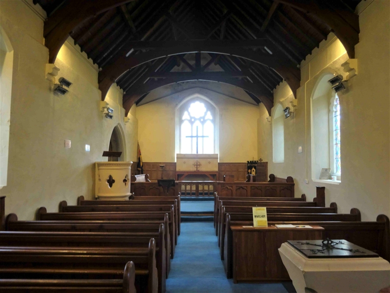
The church is entered by the south porch. The nave is short, with two banks of simply moulded pews in pitch pine. Rounded stone pulpit with quatrefoil piercings at left. Square C19 Gothic font on octagonal base near door. The floor is of red herringbone tiles.
The nave and chancel are of five bays, with arch-braced collar-beam trusses on corbels. Two steps up to the chancel, with a low pitch-pine screen. Plain choir-stalls incorporating a prayer desk at right. Single step to sanctuary and single altar step. The floors of the chancel and sanctuary are of black and red quarry tiles with encaustic tile inserts. Oak reredos against the full width of the east wall and returning at north and south, dated 1941. At the left of the chancel is a single arch and lobby leading to the vestry.
Small brass plaque at right of nave to Jane Lloyd [1881] who donated £200 to the restoration; three other brass memorials.
A church within an early round churchyard at the focus of an interesting village layout, which has undergone unpretentious late C19 restoration.
External links are from the relevant listing authority and, where applicable, Wikidata. Wikidata IDs may be related buildings as well as this specific building. If you want to add or update a link, you will need to do so by editing the Wikidata entry.


Other nearby listed buildings
