History in Structure

Cart-shed and granary to W of Ty-du Farmhouse

A Grade II Listed Building in Ceiriog Ucha, Wrexham

More Photos »
Approximate Location Map
Large Map »

Coordinates

Latitude: 52.8973 / 52°53'50"N

Longitude: -3.2138 / 3°12'49"W

OS Eastings: 318445

OS Northings: 334011

OS Grid: SJ184340

Mapcode National: GBR 6W.PKTY

Mapcode Global: WH78H.LFVP

Plus Code: 9C4RVQWP+WF

Entry Name: Cart-shed and granary to W of Ty-du Farmhouse

Listing Date: 23 May 2003

Last Amended: 23 May 2003

Grade: II

Source: Cadw

Source ID: 81163

Building Class: Agriculture and Subsistence

ID on this website: 300081163

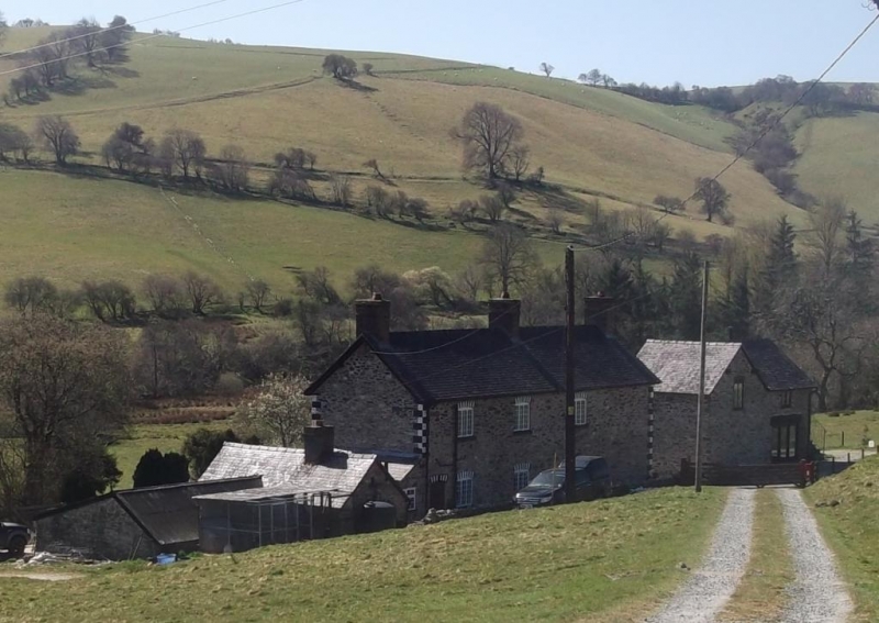
Location: Located immediately to the W of, and aligned with the farmhouse.

County: Wrexham

Community: Ceiriog Ucha

Community: Ceiriog Ucha

Locality: Pont Ricket

Traditional County: Denbighshire

Tagged with: Granary

Find accommodation in
Llanarmon Dyffryn-Ceiriog

History

Mainly late C19 and contemporary with the remodelling of the farmhouse. Appears to incorporate an earlier structure shown on the Llangadwaladr tithe map of 1839.

Exterior

Cart-shed and granary of rubble stone under a slate roof. Main range facing N with gabled cross-wing to L. Cart-shed opening to R with large timber lintel; loft hatch opening above. Cross wing gable contains a further loft hatch with segmental brick head. W gable of main range contains loft door to granary reached by external stairs. Further farm ranges adjoining rear of cross-wing.

Interior

No access to interior at time of inspection.

Reasons for Listing

Listed for group value with farmhouse and service building to E, and as a good later C19 farm building.

External Links

External links are from the relevant listing authority and, where applicable, Wikidata. Wikidata IDs may be related buildings as well as this specific building. If you want to add or update a link, you will need to do so by editing the Wikidata entry.

Recommended Books

Other nearby listed buildings

  • II Ty-du
    Set down from the B4500 and reached by a short track, approx 0.7km E of Tregeiriog. Flanked by late C19 outbuildings in the same style.
  • II Service Building to E of Ty-du Farmhouse
    Located immediately to the E of, and aligned with the farmhouse.
  • II Pontricket Farmhouse
    Reached by a short driveway. The farmhouse is built on the slope, with uphill N gable-end towards the road and entrance facing E.
  • II Pont Ricket
    The bridge carries a narrow lane which runs S from the B4500 over the River Ceiriog. It is approx 150m from the main road.
  • II Hendre
    Located at the end of a short track which runs NE from Pont Ricket.
  • II Farm Building to SE of Hendre Farmhouse
    Located across the farmyard and to the SE of the farmhouse.
  • II Small Barn at Hendre
    Up-slope and E of the house at Hendre, facing the Large Barn across a small yard.
  • II Pont y Felin
    Located 300m S of the main crossroads in Tregeiriog, and carrying the lane to Rhiwlas over the River Ceiriog.

BritishListedBuildings.co.uk is an independent online resource and is not associated with any government department. All government data published here is used under licence. Please do not contact BritishListedBuildings.co.uk for any queries related to any individual listed building, planning permission related to listed buildings or the listing process itself.

British Listed Buildings is a Good Stuff website.