Approximate Location Map
Large Map »
Latitude: 52.949 / 52°56'56"N
Longitude: -3.9951 / 3°59'42"W
OS Eastings: 266052
OS Northings: 340932
OS Grid: SH660409
Mapcode National: GBR 5W.L80B
Mapcode Global: WH55N.L4SK
Plus Code: 9C4RW2X3+JX
Entry Name: Milestone at the Oakeley Arms
Listing Date: 25 February 2005
Last Amended: 25 February 2005
Grade: II
Source: Cadw
Source ID: 84012
Building Class: Transport
ID on this website: 300084012
Location: Set at the N side of the A487(T) at its junction with the B4410, to NE end of the small hamlet of Tan-y-bwlch. The milestone is set in a wall at the S corner of the Oakeley Arms.
County: Gwynedd
Community: Maentwrog
Community: Maentwrog
Locality: Tan-y-bwlch
Traditional County: Merionethshire
Tagged with: Milestone
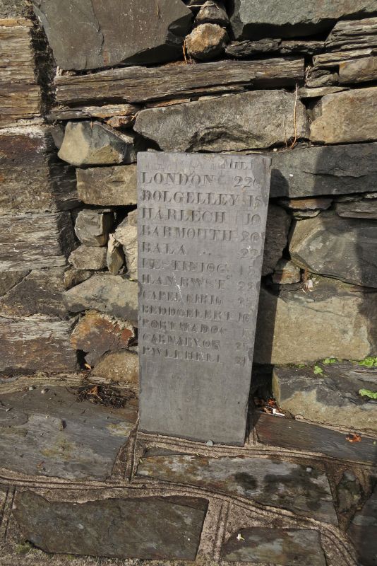
Probably early C19 milestone. Merioneth was the last of the Welsh counties to have turnpike roads and it was at a county meeting in Dolgellau in 1775 that it was resolved to convert the principal tracks of the county into turnpikes, in partnership with Caernarfonshire. By the end of the C18 most of the existing roads had been brought under the Trust under the Merioneth Turnpike Act of 1777. The milestone was probably erected in the early C19, possibly contemporary with the refacing of the adjacent public house and hotel, and utilising the slate quarried from the estate quarry at Blaenau Ffestiniog.
Rectangular slate milestone that bears the inscription:
MILES / LONDON 226 / DOLGELLEY 18 / HARLECH 10 / BARMOUTH 20 / BALA 22 / FESTINIOG 3 / LLANRWST 22 / CAPEL CERIG 23 / BEDDGELERT 10 / PORTMADOC 7 / CARNARVON 23 / PWLLHELI 21.
(1 mile = 1.609 kms)
Listed as an early C19 milestone that forms a group with the adjacent public house and hotel and cartshed at The Oakeley Arms.
External links are from the relevant listing authority and, where applicable, Wikidata. Wikidata IDs may be related buildings as well as this specific building. If you want to add or update a link, you will need to do so by editing the Wikidata entry.


Other nearby listed buildings
