History in Structure

No.1

A Grade II Listed Building in Llangurig, Powys

More Photos »
Approximate Location Map
Large Map »

Coordinates

Latitude: 52.407 / 52°24'25"N

Longitude: -3.606 / 3°36'21"W

OS Eastings: 290849

OS Northings: 279989

OS Grid: SN908799

Mapcode National: GBR 9D.PGTP

Mapcode Global: VH5C2.GR1N

Plus Code: 9C4RC94V+QJ

Entry Name: No.1

Listing Date: 24 March 2005

Last Amended: 24 March 2005

Grade: II

Source: Cadw

Source ID: 84281

ID on this website: 300084281

Location: On the W side of a by-road which runs N towards Llanidloes, and close to the junction with the main A44.

County: Powys

Community: Llangurig

Community: Llangurig

Traditional County: Montgomeryshire

Tagged with: Building

Find accommodation in
Llangurig

History

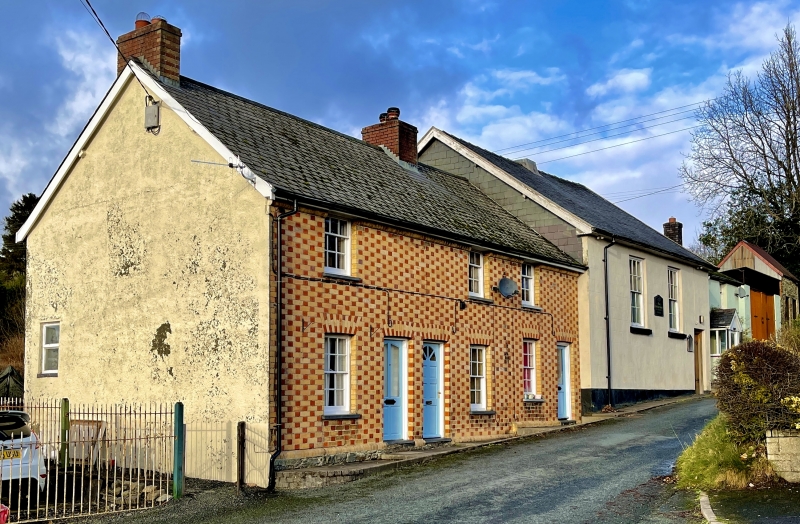
A row of 3 small cottages adjacent to a Wesleyan chapel. They are late C19, but the stone plinth may relate to an earlier terrace; nothing is shown in this location on the Tithe map of 1846. A documentary source refers to a renovation in 1894.

Exterior

No. 1 is at the S end of the group.

Interior

Interior not seen at resurvey.

Reasons for Listing

Listed for the special character of these late C19 cottages, imparted particularly by the polychrome brickwork.

External Links

External links are from the relevant listing authority and, where applicable, Wikidata. Wikidata IDs may be related buildings as well as this specific building. If you want to add or update a link, you will need to do so by editing the Wikidata entry.

Recommended Books

Other nearby listed buildings

  • II No.2
    On the W side of a by-road which runs N towards Llanidloes, and close to the junction with the main A44.
  • II No.3
    On the W side of a by-road which runs N towards Llanidloes, and close to the junction with the main A44.
  • II The Blue Bell Inn
    Fronting the N side of the main road, opposite the church. It is at the junction with a by-road which runs N towards Llanidloes.
  • II Memorial Fountain
    On the N side of the main road in the centre of Llangurig, to the E of the church. Flanked by low rubble walls retaining the village green.
  • II Lychgate at Church of St Curig
    On the S side of the A44 and forming the main entrance to the church.
  • II Memorial to Chevalier Lloyd
    In the centre of the village. Located on the pavement, immediately E of the lychgate.
  • II Milestone
    In the centre of the village, on the N side of the main road, immediately R of the water-fountain.
  • II* Church of St Curig
    On the SW side of the village, reached from the main road and set down towards the N bank of the River Wye.

BritishListedBuildings.co.uk is an independent online resource and is not associated with any government department. All government data published here is used under licence. Please do not contact BritishListedBuildings.co.uk for any queries related to any individual listed building, planning permission related to listed buildings or the listing process itself.

British Listed Buildings is a Good Stuff website.