Approximate Location Map
Large Map »
Latitude: 52.4066 / 52°24'23"N
Longitude: -3.6064 / 3°36'23"W
OS Eastings: 290818
OS Northings: 279950
OS Grid: SN908799
Mapcode National: GBR 9D.PGQJ
Mapcode Global: VH5C2.FRSY
Plus Code: 9C4RC94V+MC
Entry Name: The Blue Bell Inn
Listing Date: 24 March 2005
Last Amended: 24 March 2005
Grade: II
Source: Cadw
Source ID: 84301
Also known as: The Blue Bell
Blue Bell
The Blue Bell, Llanidloes
ID on this website: 300084301
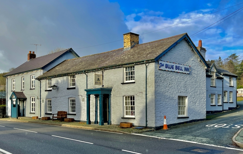
A 3-unit lobby-entry house, probably C17-18, later converted to an Inn. It is shown in its current L-shaped form on the Llangurig Tithe map of 1846, where it is recorded as 'House, garden and croft'. Some alterations occurred in the mid-late C19 perhaps on its conversion to an Inn; the stack was rebuilt in brick, it was re-roofed and possibly raised, and brick heads were added to the windows. When recorded c1970, the Inn had back-to-back fireplaces in the former hall and parlour, but the wall between hall and inner room had been removed to make an open-plan bar area.
A 3-window 2-storey range with lobby-entrance offset to R of centre; long rear wing offset to R, resulting in an L-shaped plan. Constructed of random stone painted blue, under a slate roof with wide boarded eaves; yellow brick ridge stack. Flat-roofed wooden porch with moulded cornice supported on chamfered square-section posts with ringed capitals and bases. Inside the porch are double panelled doors. The front has sash windows, 16-pane to lower storey, those to L of entrance with segmental brick heads, the window to R with stone surround and flat head. Upper storey has 4-over-8-pane sashes immediately under the eaves. A modernised house adjoins the W end of the Inn. The E gable end has a 16-pane sash under flat brick head to ground floor. Long rear wing of one-and-a-half storeys, with C19 detail. Its E side, fronting the road, is of brick and has a lateral brick stack to L of centre. The ground floor has pairs of horned 12-pane sash windows under segmental heads to L and R; wide late C20 window lighting kitchen to R of centre, adjacent to stack. Upper storey is 3-window, with 2 gabled half-dormers with 12-pane sashes to L and centre; 3-over-6-pane sash to R. The N gable end is of random stone and has no openings; W side of wing not seen.
Interior not seen at resurvey.
Listed as a sub-medieval regional house, converted to an Inn during the C19, which retains definite historic character and detail. Group value with surrounding structures in the centre of the village.
External links are from the relevant listing authority and, where applicable, Wikidata. Wikidata IDs may be related buildings as well as this specific building. If you want to add or update a link, you will need to do so by editing the Wikidata entry.


Other nearby listed buildings
