History in Structure

Milepost on A493

A Grade II Listed Building in Llangelynin, Gwynedd

More Photos »
Approximate Location Map
Large Map »

Coordinates

Latitude: 52.6398 / 52°38'23"N

Longitude: -4.1131 / 4°6'47"W

OS Eastings: 257113

OS Northings: 306767

OS Grid: SH571067

Mapcode National: GBR 8Q.6XL2

Mapcode Global: WH56Y.SXK4

Plus Code: 9C4QJVQP+WQ

Entry Name: Milepost on A493

Listing Date: 7 June 2005

Last Amended: 7 June 2005

Grade: II

Source: Cadw

Source ID: 84476

ID on this website: 300084476

Location: Approximately 450m S of Llangelynin church.

County: Gwynedd

Community: Llangelynin (Llangelynnin)

Community: Llangelynin

Traditional County: Merionethshire

Tagged with: Milestone

Find accommodation in
Llwyngwril

History

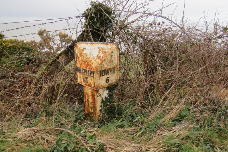
A late C19 mile marker, replacing an original milestone, on the Turnpike route from Tywyn to Dolgellau.

Exterior

A late C19 triangular cast iron mile-marker with ramped top, painted black and white with raised letters and numerals. It reads 'Dolgelley 13' and 'Towyn 6'. (1mile=1.61km)

Reasons for Listing

Listed for its special historical interest as one of a series of well-preserved mileposts on the A493 between Tywyn and Dolgellau.

External Links

External links are from the relevant listing authority and, where applicable, Wikidata. Wikidata IDs may be related buildings as well as this specific building. If you want to add or update a link, you will need to do so by editing the Wikidata entry.

Recommended Books

Other nearby listed buildings

  • I Church of St Celynin
    To the W of and below the A493 in Llangelynin hamlet. The church stands in a rectangular churchyard, and is set into the steeply sloping ground above the railway and sea.
  • II Lych gate and churchyard wall at Llangelynin church
    Enclosing a rectangular churchyard, with lych gate towards the NE corner.
  • II Felin Fraenan
    Approximately 1.3km SSW of Llangelynin church, reached by farm road through Cae-du on the S side of the A493 and below the embankment on the W side of the railway.
  • II Milepost on A493
    Nearly opposite Rhoslefain Farm and approximately 100m W of the road junction in Rhoslefain hamlet.
  • II Trefaes
    Set back and reached by a short farm track on the N side of the A493, approximately 0.7km E of Rhoslefain hamlet.
  • II Milepost on A493
    Approximately 1.2km NNE of Llangelynin church.
  • II Cow house S of Trefaes
    To the S of the house and on the W side of the track leading up to the house.
  • II Multi-purpose farm buildings at Trefaes Farm
    To the NE of the house and forming the W side of a small farmyard.

BritishListedBuildings.co.uk is an independent online resource and is not associated with any government department. All government data published here is used under licence. Please do not contact BritishListedBuildings.co.uk for any queries related to any individual listed building, planning permission related to listed buildings or the listing process itself.

British Listed Buildings is a Good Stuff website.