Approximate Location Map
Large Map »
Latitude: 51.852 / 51°51'7"N
Longitude: -3.408 / 3°24'28"W
OS Eastings: 303118
OS Northings: 217980
OS Grid: SO031179
Mapcode National: GBR YN.TH9G
Mapcode Global: VH6CB.WQ64
Plus Code: 9C3RVH2R+QR
Entry Name: Octagonal building at Lower Neuadd Reservoir
Listing Date: 28 July 2005
Last Amended: 28 July 2005
Grade: II
Source: Cadw
Source ID: 84832
Building Class: Water Supply and Drainage
ID on this website: 300084832
Location: Situated just S of the dam at Lower Neuadd Reservoir.
County: Powys
Town: Brecon
Community: Llanfrynach
Community: Llanfrynach
Locality: Neuadd
Traditional County: Brecknockshire
Tagged with: Architectural structure
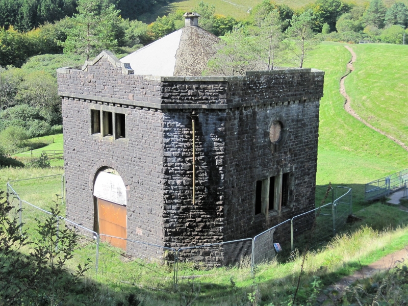
Building associated with the Lower Neuadd reservoir built c. 1900 for the Merthyr Tydfil Urban District Council.
Reservoir building, rock-faced squared stone with cemented roof. Square tower with chamfered corners, corbelled parapet and recessed octagonal roof to centre chimney. Pink stone with some sandstone ashlar. Two storeys. Front has large arched doorway, blocked, with pink stone voussoirs, and first floor has 3-light ashlar mullioned window. parapet has a small raised shouldered pediment over the window. Right side has a blocked 3-light mullioned window below and a blocked roundel above. Parapet coping is stepped up.
Not available for inspection.
Included for its special interest as a water-industry building of definite quality and character.
External links are from the relevant listing authority and, where applicable, Wikidata. Wikidata IDs may be related buildings as well as this specific building. If you want to add or update a link, you will need to do so by editing the Wikidata entry.


Other nearby listed buildings
