Approximate Location Map
Large Map »
Latitude: 51.6757 / 51°40'32"N
Longitude: -4.9163 / 4°54'58"W
OS Eastings: 198462
OS Northings: 201459
OS Grid: SM984014
Mapcode National: GBR G8.WF5Y
Mapcode Global: VH1S6.Q4TS
Plus Code: 9C3QM3GM+7F
Entry Name: Barclays Bank
Listing Date: 29 July 2005
Last Amended: 29 July 2005
Grade: II
Source: Cadw
Source ID: 84964
Building Class: Commercial
ID on this website: 300084964
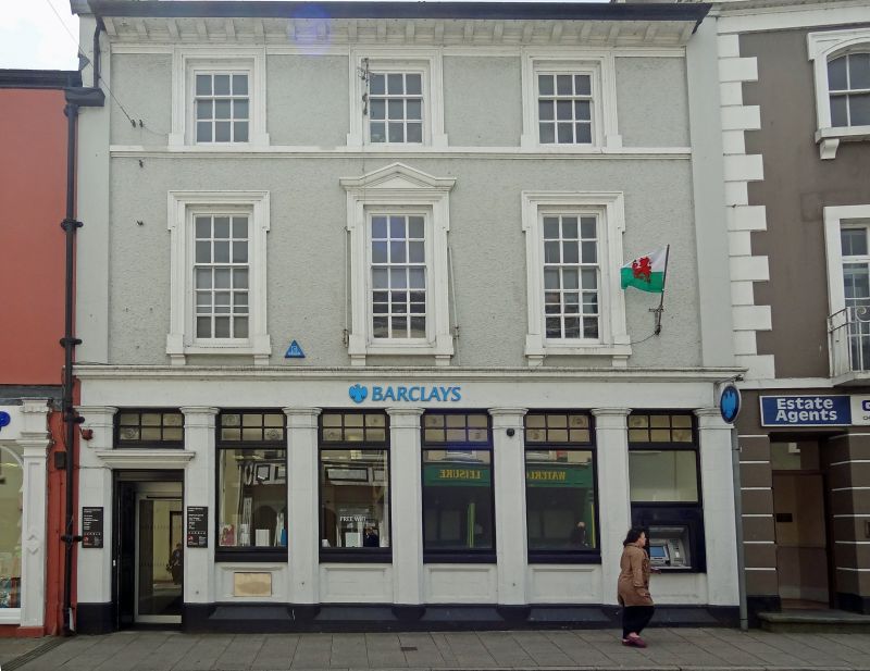
Bank building, earlier C19 terraced house, front remodelled in 1925 for Barclays Bank to plans by J. H. Morgan of Carmarthen. The building was then called Bank House, but it is not known how long it had been a bank. Old photographs show a plain terraced house with two ground floor canted bays and centre pedimented doorcase.
Bank premises, painted roughcast with stucco dressings and painted stone or artificial stone ground floor bank front. Slate roof, rendered right end stack. Three storeys, three-window range. Upper floors have raised angle pilasters, the caps slightly higher than deep bracketed eaves. Windows in moulded surrounds, top floor nine-pane sashes with moulded sill course, first floor long 15-pane sashes, the surrounds shouldered with brackets to sills and centre window with shallow shouldered pediment. Ground floor six-bay front with overall frieze and cornice. Seven chamfered pilasters with moulded caps, neck rings. Deep chamfered plinth between pilaster bases, sunk panels under five C20 plate glass windows with 6-pane top lights, the right window altered for cash dispenser. Left bay has similar overlight but over a moulded cornice over double panelled doors.
Rear has modern dry dash render and two storey SW rear wing, all windows modern. Main building to right has one modern first floor window and modern flat-roofed ground floor addition.
Interior of ground floor all altered.
Included for its special architectural interest as a well-detailed earlier C20 remodelling of an early C19 building.
External links are from the relevant listing authority and, where applicable, Wikidata. Wikidata IDs may be related buildings as well as this specific building. If you want to add or update a link, you will need to do so by editing the Wikidata entry.


Other nearby listed buildings
