Approximate Location Map
Large Map »
Latitude: 53.2374 / 53°14'14"N
Longitude: -4.1225 / 4°7'21"W
OS Eastings: 258442
OS Northings: 373257
OS Grid: SH584732
Mapcode National: GBR 5Q.011B
Mapcode Global: WH541.NW3H
Plus Code: 9C5Q6VPG+XX
Entry Name: Garth Jetty
Listing Date: 24 August 2005
Last Amended: 24 August 2005
Grade: II
Source: Cadw
Source ID: 84990
Building Class: Transport
ID on this website: 300084990
Location: Immediately alongside the pier, on its east side.
County: Gwynedd
Community: Bangor
Community: Bangor
Built-Up Area: Bangor
Traditional County: Caernarfonshire
Tagged with: Architectural structure
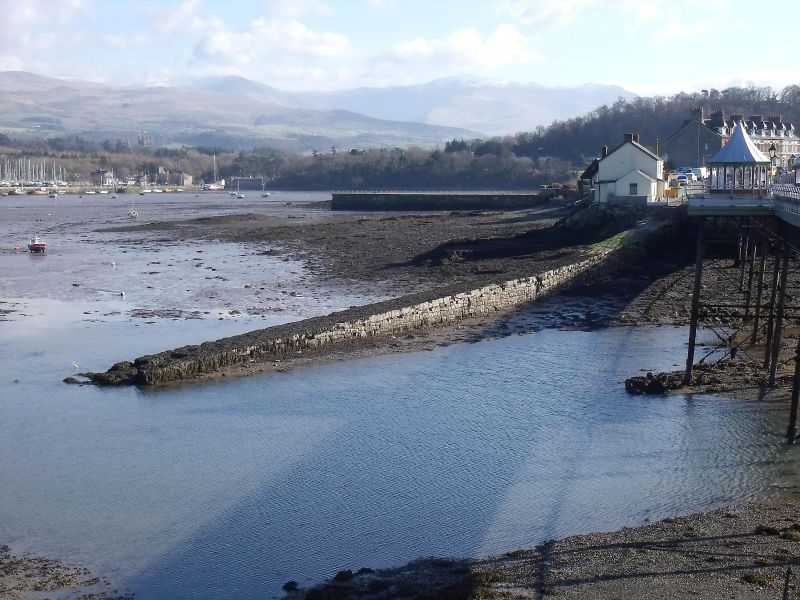
The jetty was marked as a pier on the 1831 Ordnance Survey map of the area, and marks the site of an early crossing point to Anglesey. Garth Ferry was an important crossing point before the construction of the Menai Bridge in 1826, and it is likely that the jetty belongs to this pre-bridge history. A ferry continued to operate from this jetty until the 1960's.
A low and narrow stone jetty, some 100 metres in length, sloping downwards to the water-line. Roughly coursed and squared stonework with large blocks forming its flat surface.
Listed as a virtually unaltered pre-1840 stone jetty, which forms an important component of the transport history associated with the Menai Strait.
External links are from the relevant listing authority and, where applicable, Wikidata. Wikidata IDs may be related buildings as well as this specific building. If you want to add or update a link, you will need to do so by editing the Wikidata entry.


Other nearby listed buildings
