Approximate Location Map
Large Map »
Latitude: 53.2207 / 53°13'14"N
Longitude: -2.9991 / 2°59'56"W
OS Eastings: 333387
OS Northings: 369760
OS Grid: SJ333697
Mapcode National: GBR 75.13Z5
Mapcode Global: WH885.X90S
Plus Code: 9C5V62C2+79
Entry Name: Old Marsh Farm
Listing Date: 24 August 2005
Last Amended: 24 August 2005
Grade: II
Source: Cadw
Source ID: 85248
ID on this website: 300085248
Location: Fronting the E side of the main A550 road.
County: Flintshire
Town: Deeside
Community: Sealand
Community: Sealand
Built-Up Area: Deeside Industrial Park
Traditional County: Flintshire
Tagged with: Architectural structure
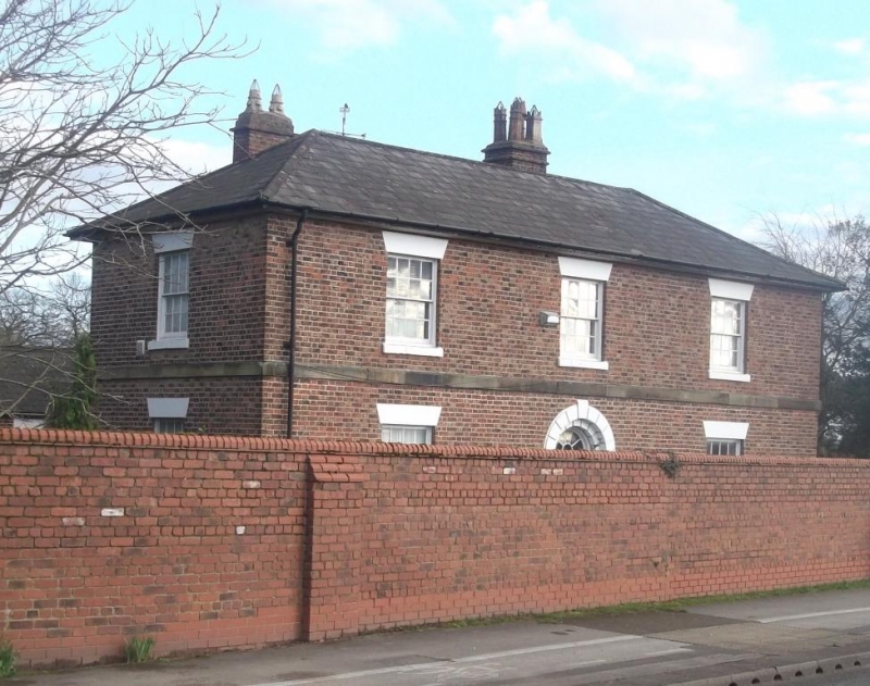
Large farm of c1850, one of several owned by the River Dee Company (1741-1902), which had a right to reclaim the marshes and build embankments following the re-alignment of the Dee. Old Marsh Farm was sold to a private owner in 1906 after the company was wound up. There is a large E-shaped group of contemporary farm buildings to the N, some now converted to industrial units. The house formerly had a large garden to the W, recently truncated by the A550 road, and is now divided into 3 apartments.
Large L-shaped 2-storey farmhouse with W range to front and S range. Constructed of brick under a shallow hipped slate roof with 3 brick stacks set behind ridge. Detail includes wide boarded eaves, dressed stone plat band and plinth. The windows are 16-pane hornless sashes with wedge lintels and stone sills. Symmetrical 3-window front with central round-arched entrance; stone doorcase with rusticated arch and keystone, inside which is a half-glazed panelled door under an overlight with radial glazing bars. N gable end of W range has a 16-pane sash to each storey. South range is 4-window and asymmetrical; eared stone doorcase to R of centre containing a glazed and panelled door under a 4-pane overlight. Sashes as elsewhere, those to the R-hand bay blind.
Three-sided courtyard to rear (N), the E side formed by a later kitchen wing. N elevation of S range is 3-window: ground floor with panelled door under a stone lintel flanked by wide 20-pane sashes, under a continuous slate-covered lean-to porch. Upper storey has 3 x 16-pane sashes as front. E elevation of W range has narrow full-height unit with hipped roof in angle of the 2 ranges; this has a panelled door and small sashes to R and upper storey; similar single-storey unit adjoining to R, also with small sash. Kitchen wing is single-storey with brick ridge stack; boarded door to L, 3-light wooden casement to R, further entrance to R end. This wing forms the end of a former carriage and stable range now converted to accommodation.
Interior not seen at time of survey.
Listed as a large mid C19 farmhouse retaining definite architectural character and well-preserved detail.
External links are from the relevant listing authority and, where applicable, Wikidata. Wikidata IDs may be related buildings as well as this specific building. If you want to add or update a link, you will need to do so by editing the Wikidata entry.


Other nearby listed buildings
