History in Structure

11, High Street Inferior

A Grade II Listed Building in Brecon, Powys

More Photos »
Approximate Location Map
Large Map »

Coordinates

Latitude: 51.9476 / 51°56'51"N

Longitude: -3.3909 / 3°23'27"W

OS Eastings: 304495

OS Northings: 228595

OS Grid: SO044285

Mapcode National: GBR YP.MFHT

Mapcode Global: VH6BZ.59PS

Plus Code: 9C3RWJX5+3J

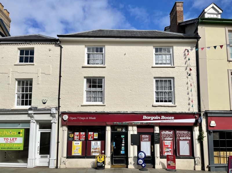
Entry Name: 11, High Street Inferior

Listing Date: 16 December 1976

Last Amended: 4 November 2005

Grade: II

Source: Cadw

Source ID: 85601

ID on this website: 300085601

Location: About 30 metres NW of Town Hall. Shown on OS map as Nos 13 and 14 but known to local authority as Nos 10 to 12.

County: Powys

Town: Brecon

Community: Brecon (Aberhonddu)

Community: Brecon

Built-Up Area: Brecon

Traditional County: Brecknockshire

Tagged with: Building

Find accommodation in
Brecon

History

Earlier C19.

Reasons for Listing

Early-to-mid C19 buildings retaining historic character; Group Value with adjacent listed buildings in High Street.

External Links

External links are from the relevant listing authority and, where applicable, Wikidata. Wikidata IDs may be related buildings as well as this specific building. If you want to add or update a link, you will need to do so by editing the Wikidata entry.

Recommended Books

Other nearby listed buildings

  • II 12, High Street Inferior
    About 30 metres NW of Town Hall. Shown on OS map as Nos 13 and 14 but known to local authority as Nos 10 to 12.
  • II NO.9 High Street Inferior, Powys
    About 20 metres NW of town hall. Shown on OS map as No 12 but known to local authority and to occupiers as No 9.
  • II NOS.10, 11 & 12 High Street Inferior, Powys
    About 30 metres NW of Town Hall. Shown on OS map as Nos 13 and 14 but known to local authority as Nos 10 to 12.
  • II NO.13 High Street Inferior, Powys
    About 40 metres NW of town hall, where street line bends. Shown on OS map as No 15 but known to local authority as No 13.
  • II 8 High Street Inferior
    About 20 metres NW of town hall. Shown on OS map as No 11; known to local authority and owners as No 8 and originally listed as such.
  • II Warwick House
    Where High Street narrows, opposite free-standing block. Shown as Nos 16 and 17 on OS map but bear numbers as Nos 14 to 17 (consec).
  • II NO.7 High Street Inferior, Powys
    Attached to Town Hall on R. Shown on the OS map as No 10 but known to the local authority and to the occupier as No 7.
  • II Town Hall
    On corner with Tredegar Street.

BritishListedBuildings.co.uk is an independent online resource and is not associated with any government department. All government data published here is used under licence. Please do not contact BritishListedBuildings.co.uk for any queries related to any individual listed building, planning permission related to listed buildings or the listing process itself.

British Listed Buildings is a Good Stuff website.