History in Structure

Seat at Hall Monument

A Grade II Listed Building in Llanover, Monmouthshire

More Photos »
Approximate Location Map
Large Map »

Coordinates

Latitude: 51.7791 / 51°46'44"N

Longitude: -2.9906 / 2°59'26"W

OS Eastings: 331756

OS Northings: 209396

OS Grid: SO317093

Mapcode National: GBR F6.Z4TV

Mapcode Global: VH79F.3KV1

Plus Code: 9C3VQ2H5+JQ

Entry Name: Seat at Hall Monument

Listing Date: 9 December 2005

Last Amended: 9 December 2005

Grade: II

Source: Cadw

Source ID: 87190

ID on this website: 300087190

Location: Set within the Hall monument enclosure and against the churchyard wall to the south-west of the church.

County: Monmouthshire

Town: Abergavenny

Community: Llanover (Llanofer)

Community: Llanover

Traditional County: Monmouthshire

Tagged with: Architectural structure
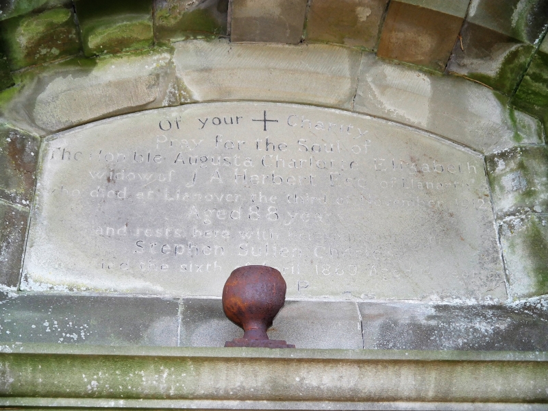
Find accommodation in
Llanover

History

c1912.

Exterior

Built probably of Bath stone ashlar. Classical design of an Edwardian Baroque type. Rusticated piers frame a recessed oak bench. A cornice crosses the recess and the piers continue above to carry a swan-neck cornice with rusticated arch and central keystone below. This frames a recess containing an inscribed stone panel.

Reasons for Listing

Included for its special interest as part of a fine monument to an important local landowner and notable Victorian politician. It also has strong group value with the adjoining church.

External Links

External links are from the relevant listing authority and, where applicable, Wikidata. Wikidata IDs may be related buildings as well as this specific building. If you want to add or update a link, you will need to do so by editing the Wikidata entry.

Recommended Books

Other nearby listed buildings

  • II Hall Monument
    Set within the Hall monument enclosure against the churchyard wall to the south-west of the church.
  • II Cross in Churchyard of Church of St. Bartholomew
    On the south side of the church.
  • II* Church of St. Bartholomew
    About 1200m north of Llanover village by the River Usk and on the west side of the minor road from Llanellen to Llanfair Kilgeddin.
  • II The Old Schoolhouse
    About 500m south of the Church of St. Bartholomew on the east side of the road from Llanellen to Llanfair Kilgeddin.
  • II The Old School
    About 500m south of the Church of St. Bartholomew on the east side of the road from Llanellen to Llanfair Kilgeddin. The Old School is set back from the road beyond the Old School House.
  • II The Old Rectory
    About 400m north of the Church of St. Bartholomew on the west side of the road from Llanellen to Llanfair Kilgeddin.
  • II Old Stable Block (ruin) at Llanover Park
    In the centre of Llanover Park on the east side of the A4052 and approached via Porth-y-pentre.
  • II Fro Fawr
    About 800 metres ESE of Llanover Church.

BritishListedBuildings.co.uk is an independent online resource and is not associated with any government department. All government data published here is used under licence. Please do not contact BritishListedBuildings.co.uk for any queries related to any individual listed building, planning permission related to listed buildings or the listing process itself.

British Listed Buildings is a Good Stuff website.