Approximate Location Map
Large Map »
Latitude: 53.1091 / 53°6'32"N
Longitude: -3.3284 / 3°19'42"W
OS Eastings: 311169
OS Northings: 357698
OS Grid: SJ111576
Mapcode National: GBR 6R.81ZF
Mapcode Global: WH77G.V36V
Plus Code: 9C5R4M5C+JJ
Entry Name: Outbuilding at Ty Gwyn
Listing Date: 30 December 2005
Last Amended: 30 December 2005
Grade: II
Source: Cadw
Source ID: 87338
ID on this website: 300087338
Location: Located to the SW of Ty Gwyn. Orientated at right angles to the house, the front facing N.
County: Denbighshire
Town: Ruthin
Community: Ruthin (Rhuthun)
Community: Ruthin
Locality: Llanfwrog
Traditional County: Denbighshire
Tagged with: Appendage
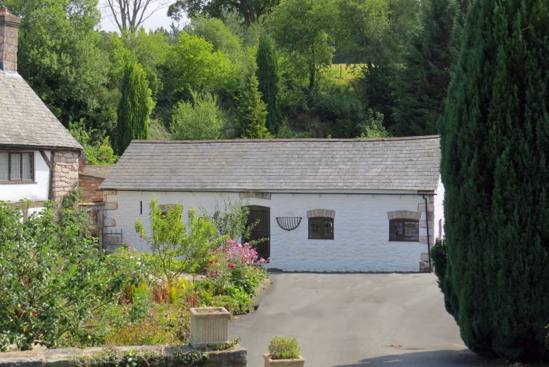
Probably mid-C19; a small multi-purpose farm-building, possibly incorporating a barn and cow-house. Shown on the Ordnance Survey of 1874.
Single-storey range constructed of white-washed random stone under a slate roof; large stone quoins. Openings to front have segmental heads of stone voussoirs. Central doorway leading to through-passage, lowered and containing split doors with segmental head. Two openings to R and one to L, asymmetrically arranged, with late C20 2-light wooden casements with quarries; the 2 windows to R may have been narrow doorways originally. Ventilation slits to far L. Rear elevation has opposing doorway with boarded door under timber lintel; small opening above, probably for an overlight or timber boarding. Small C20 2-light casement to far L and very small light to R of doorway; ventilation slits to each side. W gable end has 2-light window as front under segmental head of stone voussoirs, offset to L; E gable end has earlier 2-light wooden casement without glazing, offset to R.
Interior not inspected.
Listed as a small multi-purpose farm building retaining its character, and for group value with Ty Gwyn.
External links are from the relevant listing authority and, where applicable, Wikidata. Wikidata IDs may be related buildings as well as this specific building. If you want to add or update a link, you will need to do so by editing the Wikidata entry.


Other nearby listed buildings
