Approximate Location Map
Large Map »
Latitude: 53.9119 / 53°54'42"N
Longitude: -2.195 / 2°11'41"W
OS Eastings: 387289
OS Northings: 446214
OS Grid: SD872462
Mapcode National: GBR FR36.LF
Mapcode Global: WHB7C.8X0X
Plus Code: 9C5VWR64+Q2
Entry Name: Newfield Edge
Listing Date: 29 January 1988
Grade: II
Source: Historic England
Source ID: 1073419
English Heritage Legacy ID: 186136
ID on this website: 101073419
Location: Town Head, Pendle, Lancashire, BB18
County: Lancashire
District: Pendle
Civil Parish: Barnoldswick
Built-Up Area: Barnoldswick
Traditional County: Yorkshire
Lieutenancy Area (Ceremonial County): Lancashire
Tagged with: Building
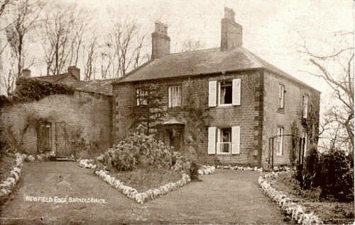
SD 84 NE BARNOLDSWICK FOLLY LANE
3/12 Newfield Edge
-
- II
House, c1800. Dressed stone with ashlar quoins. Blue slate roof, hipped to right.
2 storeys. 3 sash windows. Doorway has moulded architrave, plain frieze and
cornice. Small radial overlight. Newfield Edge Cottage adjoining to left not
included.
Listing NGR: SD8728946214
External links are from the relevant listing authority and, where applicable, Wikidata. Wikidata IDs may be related buildings as well as this specific building. If you want to add or update a link, you will need to do so by editing the Wikidata entry.


Other nearby listed buildings
