Approximate Location Map
Large Map »
Latitude: 51.4119 / 51°24'42"N
Longitude: -0.8295 / 0°49'46"W
OS Eastings: 481501
OS Northings: 168752
OS Grid: SU815687
Mapcode National: GBR D7R.F3G
Mapcode Global: VHDX2.KRVZ
Plus Code: 9C3XC56C+Q6
Entry Name: The Ship Inn
Listing Date: 2 October 1969
Grade: II
Source: Historic England
Source ID: 1118026
English Heritage Legacy ID: 41707
ID on this website: 101118026
Location: Wokingham, Berkshire, RG40
County: Wokingham
Civil Parish: Wokingham
Built-Up Area: Wokingham
Traditional County: Berkshire
Lieutenancy Area (Ceremonial County): Berkshire
Church of England Parish: Wokingham
Church of England Diocese: Oxford
Tagged with: Inn
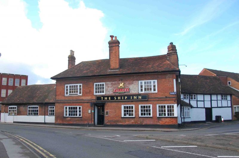
WOKINGHAM PEACH STREET
SU 8168 NW
(North side)
18/63 Nos. 104-108 (even) (The
Ship Inn)
2.10.69
G.V. II
Includes Nos. 2 and 4 Wiltshire Road.
Inn and stables, now public house. Early C18 and C19, altered late C20;
with early C16 wing facing Wiltshire Road. Part timber framed with
painted brick infill, part brick. Hipped and gabled irregular old tile
roofs. 3 framed bays wing; small irregular extensions on north, some with
thin framing. One and 2 storeys. Very large flank chimney on right of
main section with 3 truncated diamond shafts on rectangular base, one
tall chimney on front lower roof slope and one on left, both with offset
heads. All have tall clay pots. South front of main part:- black,
rendered plinth, brick string course, and raised eaves. Sash windows
with glazing bars, tripartite on both floors on left hand, on right hand on
first floor. Corner window at angle return on ground floor on right with
plain, fixed lights. Entrance lobby left of centre with pair of glazed
and panelled doors. To left of this the former one storey stables, now
with 2 segmental headed sash windows with glazing bars. East front:-
Nos. 2 and 4 Wiltshire Road, 2 storey, timber framed exposed, underbuilt
in brick. Right hand return gable in C20 brick. Irregular C19 casements,
plain central door and early C20 door and 3-light casement in angle with
main part. Interior of C16 part:- frame exposed with jowled posts, large
curved braces, redundant crown post roof with clasped purlins. This
building occupies an important corner site and together with the adjacent
Church of All Saints (listed separately) forms an important entry to the
town from the east.
Listing NGR: SU8150168752
External links are from the relevant listing authority and, where applicable, Wikidata. Wikidata IDs may be related buildings as well as this specific building. If you want to add or update a link, you will need to do so by editing the Wikidata entry.


Other nearby listed buildings
