Approximate Location Map
Large Map »
Latitude: 53.6047 / 53°36'16"N
Longitude: -1.7931 / 1°47'35"W
OS Eastings: 413789
OS Northings: 412032
OS Grid: SE137120
Mapcode National: GBR HVXR.LK
Mapcode Global: WHCB7.FNDG
Plus Code: 9C5WJ634+VQ
Entry Name: 29, Church Street
Listing Date: 4 August 1983
Grade: II
Source: Historic England
Source ID: 1134928
English Heritage Legacy ID: 340260
ID on this website: 101134928
Location: Honley, Kirklees, West Yorkshire, HD9
County: Kirklees
Civil Parish: Holme Valley
Built-Up Area: Holmfirth
Traditional County: Yorkshire
Lieutenancy Area (Ceremonial County): West Yorkshire
Church of England Parish: Honley St Mary
Church of England Diocese: Leeds
Tagged with: Building
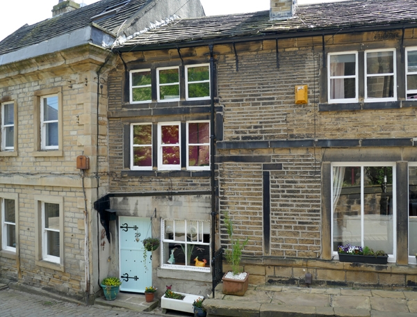
SE 1312 CHURCH STREET
9/33 (Honley)
No 29
GV
II
Part of row. Late C18. Hammer dressed stone with ground floor rendered. Stone slate
roof. Moulded eaves conrice. Three storeys. North-east: one bay. Strings between
first and second floors. Ground floor: entrance and single altered light. One
3-light stone mullioned window to first and second floors.
Listing NGR: SE1378912032
External links are from the relevant listing authority and, where applicable, Wikidata. Wikidata IDs may be related buildings as well as this specific building. If you want to add or update a link, you will need to do so by editing the Wikidata entry.


Other nearby listed buildings
