Approximate Location Map
Large Map »
Latitude: 52.8827 / 52°52'57"N
Longitude: -0.6889 / 0°41'20"W
OS Eastings: 488324
OS Northings: 332499
OS Grid: SK883324
Mapcode National: GBR DQG.6N4
Mapcode Global: WHGKN.DS6X
Plus Code: 9C4XV8M6+3C
Entry Name: Gateway and Boundary Wall to Old Manor House
Listing Date: 21 September 1979
Last Amended: 14 November 1994
Grade: II
Source: Historic England
Source ID: 1194956
English Heritage Legacy ID: 383012
ID on this website: 101194956
Location: Harlaxton, South Kesteven, Lincolnshire, NG32
County: Lincolnshire
District: South Kesteven
Civil Parish: Harlaxton
Built-Up Area: Harlaxton
Traditional County: Lincolnshire
Lieutenancy Area (Ceremonial County): Lincolnshire
Church of England Parish: Harlaxton St Mary and St Peter
Church of England Diocese: Lincoln
Tagged with: Gate
In the entry for:
HARLAXTON RECTORY LANE
SK 9239
(south side)
1315-0/14/209
21/09/79 Gateway and boundary
wall to old manor
house. (Formerly listed as
RECTORY LANE
Gatewayappox80 metres
north of old manor house
II
The last sentence of the description should be amended to read:
" This gateway and wall are a part of the remains of the Old Manor House, demolished c. 1860-
1875 by John Sherwood Gregory."
------------------------------------
HARLAXTON
SK8832 RECTORY LANE
1315-0/14/209 (South side)
21/09/79 Gateway and boundary wall to Old
Manor House
(Formerly Listed as:
RECTORY LANE
Gateway approx 80 metres north of
Old Manor House)
II
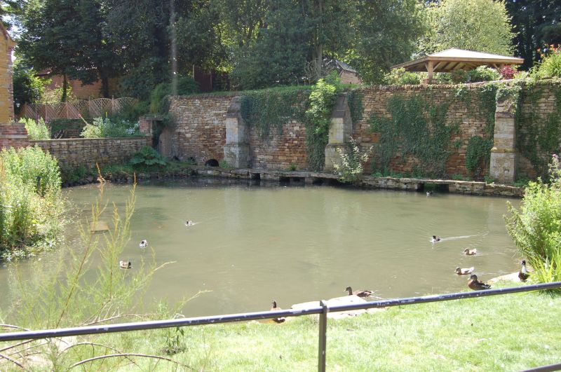
Gateway and boundary wall. c1600. Ashlar and coursed squared
stone. Renaissance Revival style. Moulded round arch with
square piers, and blank shields in the spandrels. Above the
cornice, a shouldered round gable with moulded coping and 3
finials. Boundary wall has slab coping. The length bordering
Pond Street has 4 stepped buttresses and 2 small round arched
culvert openings. Total length approx 80M.
This building is all that remains of the Old Manor House,
demolished c1860-1875 by John Sherwin Gregory.
(The Buildings of England: Pevsner N, Harris J & Antram N:
Lincolnshire: London: 1964-1989: 361-362; Rowlands G:
Harlaxton Manor: Harlaxton: 1984-: 20-29).
Listing NGR: SK8832432499
External links are from the relevant listing authority and, where applicable, Wikidata. Wikidata IDs may be related buildings as well as this specific building. If you want to add or update a link, you will need to do so by editing the Wikidata entry.


Other nearby listed buildings
