Approximate Location Map
Large Map »
Latitude: 51.3572 / 51°21'25"N
Longitude: 0.2942 / 0°17'39"E
OS Eastings: 559833
OS Northings: 164509
OS Grid: TQ598645
Mapcode National: GBR Y6.6TR
Mapcode Global: VHHPG.14WX
Plus Code: 9F32974V+VM
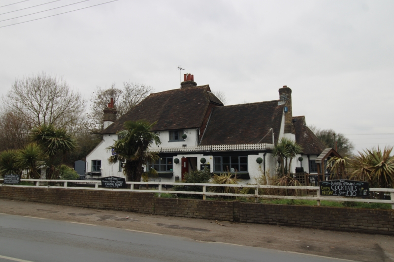
Entry Name: The White Swan Public House
Listing Date: 22 October 1982
Grade: II
Source: Historic England
Source ID: 1235102
English Heritage Legacy ID: 411254
Also known as: The White Swan, Sevenoaks
White Swan
ID on this website: 101235102
Location: Ash, Sevenoaks, Kent, TN15
County: Kent
District: Sevenoaks
Civil Parish: Ash-cum-Ridley
Built-Up Area: Ash
Traditional County: Kent
Lieutenancy Area (Ceremonial County): Kent
Church of England Parish: Ash St Peter and St Paul
Church of England Diocese: Rochester
Tagged with: Pub
ASH-CUM-RIDLEY ASH ROAD
1.
5280
The White Swan
Public House
TQ 56 SE 6/1
II
2.
C17 or earlier timber-framed building, now roughcast. Two storeys. Steeply
pitched hipped old tiled roof with gablet on one side, 3 later casements. Modern
extension.
Listing NGR: TQ5983364509
External links are from the relevant listing authority and, where applicable, Wikidata. Wikidata IDs may be related buildings as well as this specific building. If you want to add or update a link, you will need to do so by editing the Wikidata entry.


Other nearby listed buildings
