Approximate Location Map
Large Map »
Latitude: 52.0283 / 52°1'41"N
Longitude: -1.0192 / 1°1'9"W
OS Eastings: 467387
OS Northings: 237109
OS Grid: SP673371
Mapcode National: GBR 9X9.TBG
Mapcode Global: VHDT2.981Y
Plus Code: 9C4W2XHJ+88
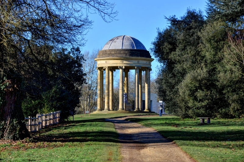
Entry Name: The Rotondo
Listing Date: 25 September 1951
Last Amended: 21 April 1983
Grade: I
Source: Historic England
Source ID: 1289655
English Heritage Legacy ID: 396657
ID on this website: 101289655
Location: Buckinghamshire, MK18
County: Buckinghamshire
Civil Parish: Stowe
Traditional County: Buckinghamshire
Lieutenancy Area (Ceremonial County): Buckinghamshire
Church of England Parish: Stowe
Church of England Diocese: Oxford
Tagged with: Architectural structure
SP 6737 STOWE
9/86 STOWE SCHOOL
The Rotondo
(formerly listed as
Vanbrugh Rotunda)
25.9.51
GV I
Circular structure with open Ionic collonade. 1721 by Vanbrugh. Dome added
by Borra before 1763.
Listing NGR: SP6738737109
External links are from the relevant listing authority and, where applicable, Wikidata. Wikidata IDs may be related buildings as well as this specific building. If you want to add or update a link, you will need to do so by editing the Wikidata entry.


Other nearby listed buildings
