Approximate Location Map
Large Map »
Latitude: 51.6712 / 51°40'16"N
Longitude: 0.384 / 0°23'2"E
OS Eastings: 564952
OS Northings: 199628
OS Grid: TQ649996
Mapcode National: GBR NJW.1YH
Mapcode Global: VHJKD.L8W6
Plus Code: 9F32M9CM+FJ
Entry Name: Baker's House
Listing Date: 30 March 1972
Last Amended: 9 December 1994
Grade: II
Source: Historic England
Source ID: 1297224
English Heritage Legacy ID: 373617
ID on this website: 101297224
Location: Ingatestone, Brentwood, Essex, CM4
County: Essex
District: Brentwood
Town: Brentwood
Civil Parish: Ingatestone and Fryerning
Built-Up Area: Ingatestone
Traditional County: Essex
Lieutenancy Area (Ceremonial County): Essex
Church of England Parish: Ingatestone St Edmund and St Mary
Church of England Diocese: Chelmsford
Tagged with: House
INGATESTONE AND FRYERNING
TQ6499 BAKERS LANE, Ingatestone
723-1/14/335 (South East side)
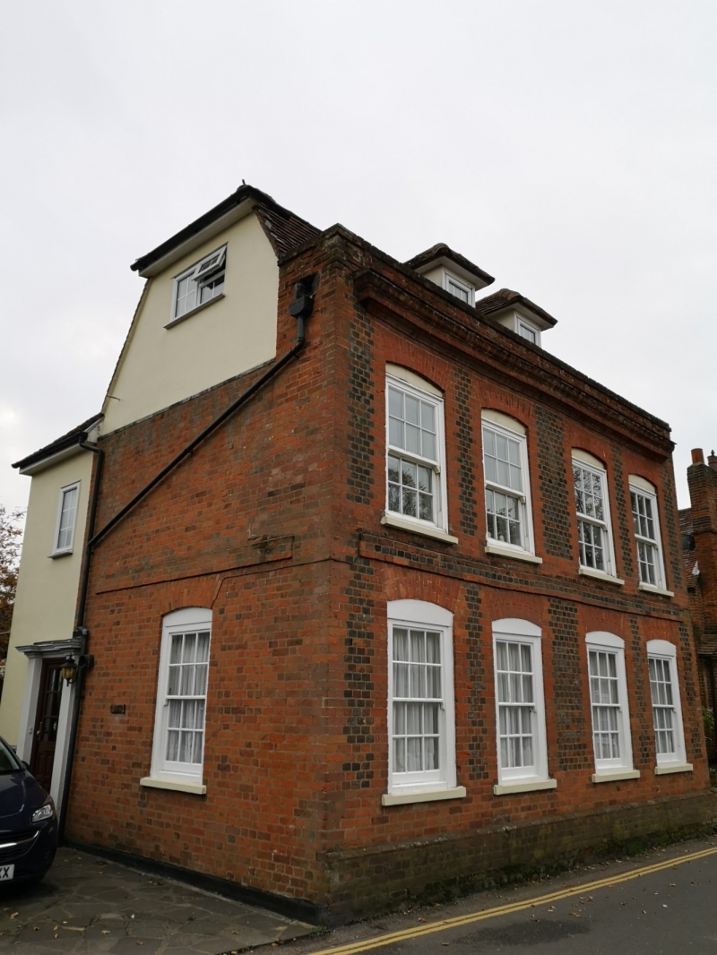
30/03/72 Nos.33 AND 35 Baker's House
(Formerly Listed as:
BRENTWOOD
BAKERS LANE, Ingatestone
Nos.33 AND 35)
GV II
House. Mid-C18, renovated and restored in 1973 by Harland and Lee; bu1lders. Blue and red bricks in header bond, roofed with handmade red clay tiles. Main range facing NW, 2 storeys and, attics; C20 2-storey wing to rear left, plastered and roofed with machine-made red clay tiles; 2-storey lean-to to rear right. 4-window range of C20 sashes of 6+6 lights with jambs and gauged segmental-flat arches of red brick. Projecting band of 3 courses of red bricks at first-floor height. Red brick quoins. Moulded brick cornice, plain parapet, half-hipped mansard roof. Two C20 casements in hipped dormers. C20 glazed door in left elevation of left rear wing, in C20 doorcase with fluted pilasters and dentilled cornice. One similar sash in each return, on the ground floor; attic storey plastered. Similar raised band on returns. All re-pointed with cement mortar. In the right return, about 4m above ground, is a brick inscribed 'I.G. 1745', probably a parish boundary mark.
Listing NGR: TQ6495299627
External links are from the relevant listing authority and, where applicable, Wikidata. Wikidata IDs may be related buildings as well as this specific building. If you want to add or update a link, you will need to do so by editing the Wikidata entry.


Other nearby listed buildings
