Approximate Location Map
Large Map »
Latitude: 54.9657 / 54°57'56"N
Longitude: -1.8651 / 1°51'54"W
OS Eastings: 408737
OS Northings: 563464
OS Grid: NZ087634
Mapcode National: GBR HCF0.0Q
Mapcode Global: WHC3M.BG31
Plus Code: 9C6WX48M+7X
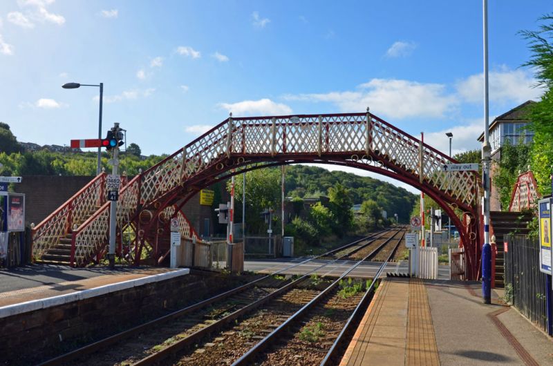
Entry Name: Footbridge at Prudhoe Station
Listing Date: 7 March 1985
Grade: II
Source: Historic England
Source ID: 1303681
English Heritage Legacy ID: 239495
ID on this website: 101303681
Location: Low Prudhoe, Northumberland, NE42
County: Northumberland
Civil Parish: Prudhoe
Built-Up Area: Prudhoe
Traditional County: Northumberland
Lieutenancy Area (Ceremonial County): Northumberland
Church of England Parish: Prudhoe St Mary Magdalene
Church of England Diocese: Newcastle
Tagged with: Railway footbridge
NZ 06 SE PRUDHOE STATION ROAD
8/140 Footbridge at Prudhoe
Station
II
Footbridge. Later C19. Iron. Supported on 2 elliptical arches. 3 iron circles
in each spandrel. Trelliswork parapet supported by S-curve stanchions with
acorn finial at each angle.
Listing NGR: NZ0873763464
External links are from the relevant listing authority and, where applicable, Wikidata. Wikidata IDs may be related buildings as well as this specific building. If you want to add or update a link, you will need to do so by editing the Wikidata entry.


Other nearby listed buildings
