Approximate Location Map
Large Map »
Latitude: 52.1044 / 52°6'15"N
Longitude: -2.0707 / 2°4'14"W
OS Eastings: 395254
OS Northings: 245119
OS Grid: SO952451
Mapcode National: GBR 2JT.58Z
Mapcode Global: VHB0R.2C5M
Plus Code: 9C4V4W3H+QP
Entry Name: Pershore Bridge (That Part in Pershore Civil Parish)
Listing Date: 11 February 1965
Last Amended: 30 March 1999
Grade: II*
Source: Historic England
Source ID: 1386991
English Heritage Legacy ID: 474407
ID on this website: 101386991
Location: Wick, Wychavon, Worcestershire, WR10
County: Worcestershire
District: Wychavon
Civil Parish: Wick
Built-Up Area: Pershore
Traditional County: Worcestershire
Lieutenancy Area (Ceremonial County): Worcestershire
Church of England Parish: Wick
Church of England Diocese: Worcester
PERSHORE
SO9545 BRIDGE STREET
648-1/5/65 (East side (off))
11/02/65 Pershore Bridge (that part in
Pershore Civil Parish)
(Formerly Listed as:
BRIDGE STREET
(East side)
Pershore Bridge (Southern Section))
GV II*
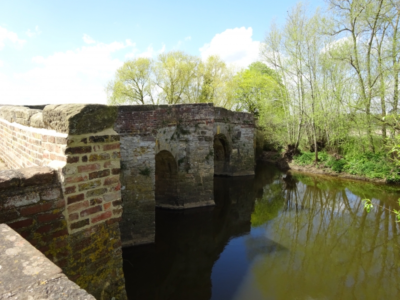
Bridge. Probably late C15, remodelled C17 and C18. Stone piers
and arches; red brick parapet with deep saddleback stone
coping; some repairs in blue brick, mostly in English or
English Garden Wall bond.
5 main elliptical stone arches with voussoirs, the central
widest with keystone, also flood-arch with keystone at N end
and further angled flood-arch at S end. 5 cutwaters and 5
refuges on east side, none on west side. Parapet has double
dogtooth string-course at base; brick and stone end piers;
parapet curved at SE corner to accommodate abutment,
flood-arch and E approach, and extending S to border main
approach.
Central arch enlarged by William Sandys c1635 when Avon made
navigable from Tewkesbury to Stratford via Pershore, and
bridge further repaired/remodelled after damage in Civil War.
See also Wick CP.
(BoE: Pevsner N: Worcestershire: Harmondsworth: 1968-: 243;
Country Life: November 17 1960).
Listing NGR: SO9525445119
External links are from the relevant listing authority and, where applicable, Wikidata. Wikidata IDs may be related buildings as well as this specific building. If you want to add or update a link, you will need to do so by editing the Wikidata entry.


Other nearby listed buildings
