History in Structure

Pont Carrog

A Grade II* Listed Building in Corwen, Denbighshire

More Photos »
Approximate Location Map
Large Map »

Coordinates

Latitude: 52.9834 / 52°59'0"N

Longitude: -3.3192 / 3°19'9"W

OS Eastings: 311528

OS Northings: 343711

OS Grid: SJ115437

Mapcode National: GBR 6R.J470

Mapcode Global: WH781.Z8LP

Plus Code: 9C4RXMMJ+98

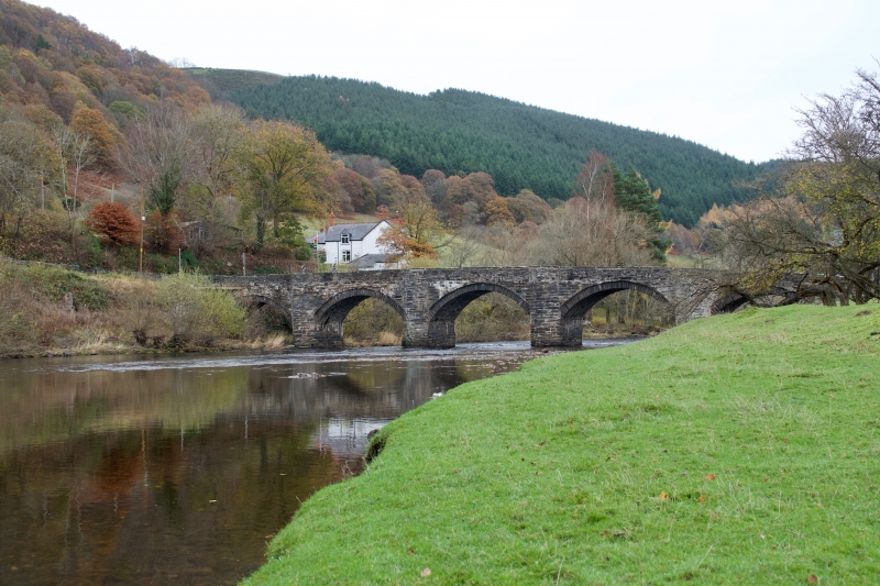
Entry Name: Pont Carrog

Listing Date: 20 October 1966

Last Amended: 1 February 1995

Grade: II*

Source: Cadw

Source ID: 675

Building Class: Transport

ID on this website: 300000675

Location: Carries the minor road from Llidiart y Parc to Carrog over the River Dee.

County: Denbighshire

Community: Corwen

Community: Corwen

Locality: Carrog

Traditional County: Merionethshire

Tagged with: Bridge Road bridge

Find accommodation in
Carrog

History

Probably late C17 (a stone built into the parapet is dated 1661).

Exterior

A 5-arched span (including 2 flood-arches) of roughly coursed slate rubble, rougher to parapet, which is carried on the projecting hood-mould above each of the voussoir arches. Cut-waters between the principal arches are taken up into the parapet.

Reasons for Listing

An exceptionally good example of a late C17 masonry bridge, and one of a series of similar early bridges crossing the Rivers Dee and Alwen.

Scheduled Ancient Monument, Ref. Me 29.

External Links

External links are from the relevant listing authority and, where applicable, Wikidata. Wikidata IDs may be related buildings as well as this specific building. If you want to add or update a link, you will need to do so by editing the Wikidata entry.

Recommended Books

Other nearby listed buildings

  • II Attached Farmbuildings to Pen-y-Bont Farmhouse
    On the left hand side of the road which leads from Llidiart y Parc to Carrog, close to the River Dee.
  • II Pen-y-Bont Farmhouse
    On the left hand side of the road which leads from Llidiart y Parc to Carrog, close to the River Dee.
  • II Church of St Bridget
    Towards the W end of the village, on the N side of the main street, in the angle with the road leading up to Morfydd.
  • II Farmbuildings at Llan Farm
    On the N of the village, on the SW side of the lane which leads to Bryneglwys via Morfydd, opposite and below Llan Farmhouse and Llan House.
  • II Llan House
    On the N edge of the village, on the NE side of the lane leading up to Bryneglwys via Morfydd.
  • II Carreg Afon Farmhouse
    Above the road on the W side of the hamlet of Llidiart y Parc.
  • II Llan Farmhouse
    On the N edge of the village, on the NE side of the lane leading up to Bryneglwys via Morfydd.
  • II Ty'n-Llwyn Farmhouse
    Down a track on the W side of the village, and close to the river.

BritishListedBuildings.co.uk is an independent online resource and is not associated with any government department. All government data published here is used under licence. Please do not contact BritishListedBuildings.co.uk for any queries related to any individual listed building, planning permission related to listed buildings or the listing process itself.

British Listed Buildings is a Good Stuff website.