Approximate Location Map
Large Map »
Latitude: 52.9808 / 52°58'50"N
Longitude: -4.1951 / 4°11'42"W
OS Eastings: 252722
OS Northings: 344862
OS Grid: SH527448
Mapcode National: GBR 5M.J7DB
Mapcode Global: WH55C.JBKP
Plus Code: 9C4QXRJ3+8X
Entry Name: Church of St Michael
Listing Date: 19 October 1971
Last Amended: 30 March 1999
Grade: II
Source: Cadw
Source ID: 4283
Building Class: Religious, Ritual and Funerary
ID on this website: 300004283
Location: The church lies in the central section of the valley, set within its large churchyard on the low lying valley floor. Within the churchyard there are a number of gravestones of the first half of the C
County: Gwynedd
Town: Dolbenmaen
Community: Dolbenmaen
Community: Dolbenmaen
Locality: Llanfihangel-y-Pennant
Traditional County: Caernarfonshire
Tagged with: Church building
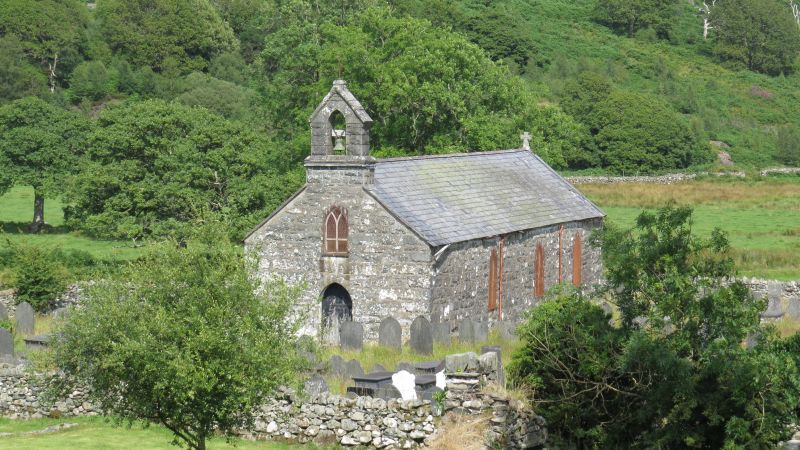
The church is perhaps C17 in origin, and the centre of a separate parish centred in the Pennant valley. It was considerably altered in the C19, with the W gallery dated 1847. Further restorations carried out in 1888. The parish registers begin in 1692.
Built of coursed stone rubble of local origin, with a slate roof. A long single cell building with a boarded W door within a pointed arch, and above, a gabled bellcote. Three pointed-headed windows each side, and a similar window over the W door, all furnished with diamond pattern lead glazing. The E window is composed of three equally sized round-headed lancets with transomed timber frames, each containing coloured glass in the upper half.
A western entrance lobby with store on the S side is formed under a western gallery. Internal walls plastered above a dado formed with C17 panelling probably from earlier box pews, and bearing the dates 1687 and ST RM 1688. Six roof trusses forming 7 bays, of collar and king-post form with knee braces carrying the roof on 2 tiers of purlins, all probably C19 or refurbished at that time. The W gallery is early C19 with panelled cornice front, raked and carrying 4 ranges of pews.
Fittings: altar rail, probably early C19, turned balusters. Two timber lecterns. Octagonal Gothic pulpit with openwork tracery sides. Simple early C19 pews.
Monuments: on the Nave S side, White marble wall tablets: (a) Jane Brynker, d.1760, erected by William Wynn of Macsyneuadd; (b) a rectangular tablet to Mrs Jane Price of Rhiwlas (Mer) d.1727, noting a royal bounty was procured for the church; (c) Catherine Price, d.1727, 'who had not the external ornaments of costly apparel' wife of James Brynker, d.1644, he 'a great sufferer for his Royal Master' added; oval marble tondo with a fine draped profile bust over. On the N side: (d) Rev Augustus Jones, d.1910; and 3 slate tablets floated into the plaster; (e) Jane Jones, d.1790; (f) 3 children of Mary Powell, d.1812, 1835 and 1837, and John Powell, a son, d.1842 in the Gulf of Mexico, aged 25; (g) Mary Powell, d.1847, with Robert Powell, d.1855.
Included as a simple C17 rural parish church in a picturesque rural setting, containing some interesting memorials, its C19 restoration scarcely influenced by gothic revival principles. Of group value with Pont Llanfihangel.
External links are from the relevant listing authority and, where applicable, Wikidata. Wikidata IDs may be related buildings as well as this specific building. If you want to add or update a link, you will need to do so by editing the Wikidata entry.


Other nearby listed buildings
