Approximate Location Map
Large Map »
Latitude: 51.8928 / 51°53'34"N
Longitude: -3.2834 / 3°17'0"W
OS Eastings: 311780
OS Northings: 222360
OS Grid: SO117223
Mapcode National: GBR YT.QXWZ
Mapcode Global: VH6C7.1PKC
Plus Code: 9C3RVPV8+4J
Entry Name: Yr Aildy
Listing Date: 17 December 1998
Last Amended: 24 January 2023
Grade: II
Source: Cadw
Source ID: 21129
Building Class: Domestic
ID on this website: 300021129
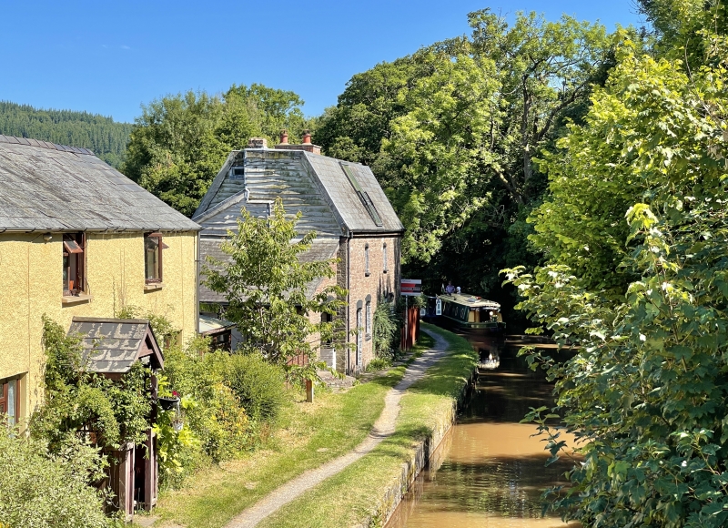
Location: Fronting the canal towpath and built into the slope, the rear facing The Travellers Rest Inn on B4558, at the SE edge of Talybont village.
County: Powys
Town: Brecon
Community: Talybont-on-Usk (Tal-y-bont ar Wysg)
Community: Talybont-on-Usk
Locality: Talybont on Usk
Traditional County: Brecknockshire
Tagged with: Cottage
Former pair of cottages, converted to single dwelling in the 1960-70s. Associated with the former Brecknock and Abergavenny Canal, this section constructed c1800.
The Brecknock and Abergavenny Canal was proposed in 1792 to connect the upper Usk valley with the Monmouthshire Canal at Pontymoile and from there to the sea at Newport. First section, between Gilwern and Talybont, was cut between 1797 and 1799, with upper section between Talybont and Brecon opened in 1800; lower section between Gilwern and Pontymoile completed 1812 and engineered by William Crosley. Linked to tramroads, the canal was an important artery for trade in iron, lime and coal. In 1865 the Brecknock and Abergavenny and Monmouthshire Canals merged to become the Monmouthshire and Brecon Canal, which was later incorporated into the Great Western Railway. Canal workers on this section of canal were last employed during WWI and the last toll was taken 1933.
The cottages had been abandoned and were derelict by the end of WWII, though are still shown on the 1953 OS provisional edition. Restoration of canal began 1964 and Yr Aildy and nearby buildings were purchased by Ifor Pew, who set about repairing and bringing them back into use. Yr Aildy was extended upwards and the current Mansard roof was created, likely replacing an original hipped roof. It was used as a furniture workshop and printing press, and was converted into a house in 1975. Much of the interior, the roof, windows, and external lean-to buildings, belong to this period and later works in the 1970s and 1980s, although the shared back-to-back fireplace is probably original.
Built as a reflected pair of canal cottages with basement storage (in the sloping ground away from the canal). 2 storey and attic to front, additional storey to rear with storage vaults extending right into bank beyond house. Stone rubble with Welsh slate part mansard roof, the vertical ends weatherboarded; brick stacks just reach ridge (due to heightening of the roof). Canalside frontage has a single segmental arched window to each floor for each former cottage with doorways at each end; to rear each cottage has a large segmental arched roof dormer, 2 segmental arched windows to first floor, one to ground floor at side, and segmental and pointed arched cellar entrances below. Lean-to front left wrapping round building to rear. Windows have yellow brick or dressed stone voussoirs (now painted) and small pane metal framed glazing with central opening casements and shallow stone sills.
4 storeys, including attic and basement. Central fireplace, full height spiral stair in SW corner.
Listed as a rare surviving example of a former pair of canalside cottages, brought back into use in the post-war period retaining much historic character. Also included for special historic interest as part of a group of buildings associated with the canal and tramroad and for its later rehabilitation as part of the wider rediscovery across the UK of inland waterways and their buildings. Group value with other listed items in Talybont and the canal.
External links are from the relevant listing authority and, where applicable, Wikidata. Wikidata IDs may be related buildings as well as this specific building. If you want to add or update a link, you will need to do so by editing the Wikidata entry.


Other nearby listed buildings
