History in Structure

Churchyard cross at Bryngwyn church

A Grade II Listed Building in Llanarth, Monmouthshire

More Photos »
Approximate Location Map
Large Map »

Coordinates

Latitude: 51.7792 / 51°46'44"N

Longitude: -2.8847 / 2°53'4"W

OS Eastings: 339064

OS Northings: 209314

OS Grid: SO390093

Mapcode National: GBR FC.Z12S

Mapcode Global: VH79G.YJCY

Plus Code: 9C3VQ4H8+M4

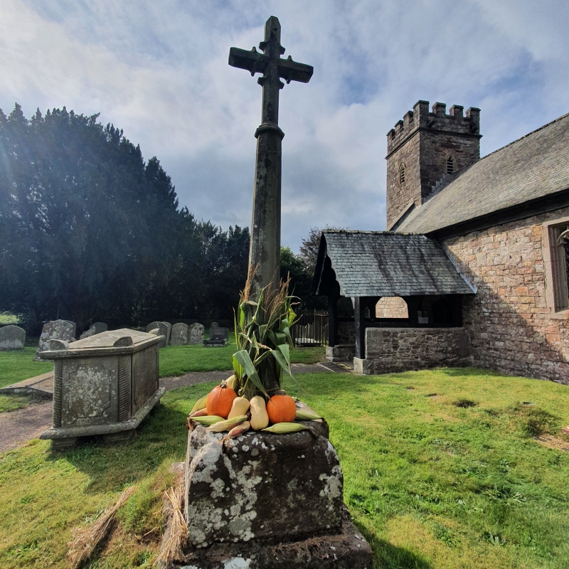
Entry Name: Churchyard cross at Bryngwyn church

Listing Date: 15 March 2000

Last Amended: 15 March 2000

Grade: II

Source: Cadw

Source ID: 23004

Building Class: Religious, Ritual and Funerary

Also known as: St. Peter's Churchyard Cross, Bryngwyn

ID on this website: 300023004

Location: Situated in churchyard to S of Bryngwyn church.

County: Monmouthshire

Town: Raglan

Community: Llanarth (Llan-arth)

Community: Llanarth

Locality: Bryngwyn

Traditional County: Monmouthshire

Tagged with: Christian cross Cross base

Find accommodation in
Bryngwyn

History

Medieval base to churchyard cross.

Exterior

Cross base, square single stone with ridged rounded haunches at angles, where square is broached to octagonal. Late C19 or early C20 octagonal cross shaft with carved Latin cross.

Reasons for Listing

Included for group value with Church of St Peter.

External Links

External links are from the relevant listing authority and, where applicable, Wikidata. Wikidata IDs may be related buildings as well as this specific building. If you want to add or update a link, you will need to do so by editing the Wikidata entry.

Recommended Books

Other nearby listed buildings

  • II* Church of Saint Peter
    Situated in Bryngwyn village, on W side of lane some 500m N of junction with old A40.
  • II Rectory Farmhouse and the Old Rectory
    Situated immediately N of Bryngwyn churchyard, Rectory Farm facing the road and backing onto the Old Rectory.
  • II Stable block at Plas Hendy
    Situated to N of Plas Hendy, facing S over rear yard.
  • II Plas Hendy
    Situated some 300m N of Bryngwyn church, on right side of lane.
  • II High House
    Situated on N side of old A 40 about 400m W of Croesbychan crossroads.
  • II Chapel Farmhouse
    Situated on W side of lane running N from old A40, some 600m N of Cripple Creek Inn.
  • II Plas yr Haul
    Situated in Greatoak village, on W side of road, opposite GPO telephone box.
  • II Telephone Call-box (01291 690495)
    Set in Greatoak village, on E side of road S of Pentre Derwen, 1914 block of estate houses.

BritishListedBuildings.co.uk is an independent online resource and is not associated with any government department. All government data published here is used under licence. Please do not contact BritishListedBuildings.co.uk for any queries related to any individual listed building, planning permission related to listed buildings or the listing process itself.

British Listed Buildings is a Good Stuff website.