History in Structure

Telephone Call-box at Forest Coalpit

A Grade II Listed Building in Crucorney (Crucornau Fawr), Monmouthshire

More Photos »
Approximate Location Map
Large Map »

Coordinates

Latitude: 51.884 / 51°53'2"N

Longitude: -3.0401 / 3°2'24"W

OS Eastings: 328510

OS Northings: 221120

OS Grid: SO285211

Mapcode National: GBR F4.RJK0

Mapcode Global: VH78T.8X62

Plus Code: 9C3RVXM5+JX

Entry Name: Telephone Call-box at Forest Coalpit

Listing Date: 1 February 2021

Grade: II

Source: Cadw

Source ID: 87821

ID on this website: 300087821

Location: 20m north of Five Ways crossing on right hand side of road.

County: Monmouthshire

Community: Crucorney (Crucornau Fawr)

Community: Crucorney

Locality: Forest Coalpit

Traditional County: Monmouthshire

History

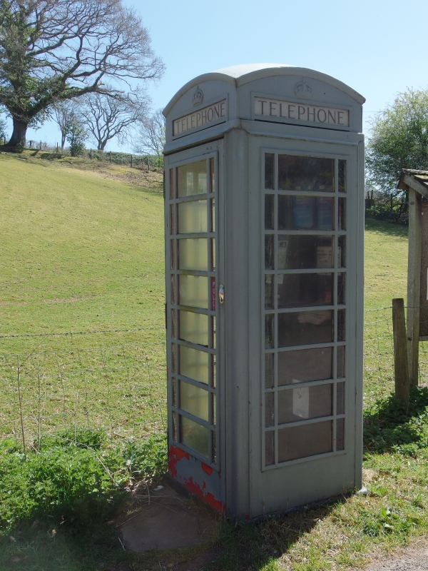
In the 1950s a number of phone boxes across the UK were painted in neutral colours in the newly established National Parks to make them less visually obtrusive – the Brecon Beacons National Park was designated in 1957. No other painted phone boxes are known to have survived in Wales's National Parks.

Exterior

K6-type telephone box of cast iron construction. Domed roof with 4 lunettes over glazed lettered panels marked 'Telephone'. Raised surrounds to sides and door with sidebar glazing to horizontal panels. Blank rear. Painted battleship grey.

Reasons for Listing

Listed for architectural interest as a classic telephone box with an unusual colour scheme, and historic interest for its link to the establishment of Brecon Beacons National Park in 1957.

External Links

External links are from the relevant listing authority and, where applicable, Wikidata. Wikidata IDs may be related buildings as well as this specific building. If you want to add or update a link, you will need to do so by editing the Wikidata entry.

Recommended Books

Other nearby listed buildings

  • II Pontyspig Cottage
    Immediately adjacent to Pontyspig on the river boundary with Powys.
  • II Pont Yspig
    Crossing the Grwyne Fawr on a minor road between Partrishow and Llanfihangel Crucorney, approximately 1.4km SSE of Partrishow church. Partly in Crucorney Community
  • II Pontyspig Farmhouse
    On the boundary between Monmouthshire and Powys about 300m from Forest Coal Pit.
  • II* Neuadd
    Approximately 0.9km S of Partrishow church, on N side and set back above a minor road between Partrishow and Llanbedr.
  • II Barn at The Pant
    About 30m south west of The Pant.
  • II Pwll-y-hwyaid Farmhouse.
    On the roadside about 200m west of the Forest Coal Pit crossroads.
  • II The Pant
    About 1km north of Forest Coal Pit up the mountain road from the cross-roads at Pont-yspig.
  • II Salem Presbyterian Chapel, with attached stable
    In the centre of the Forest Coalpit settlement about 4km west of Llanvihangel Crucorney.

BritishListedBuildings.co.uk is an independent online resource and is not associated with any government department. All government data published here is used under licence. Please do not contact BritishListedBuildings.co.uk for any queries related to any individual listed building, planning permission related to listed buildings or the listing process itself.

British Listed Buildings is a Good Stuff website.