Approximate Location Map
Large Map »
Latitude: 52.0353 / 52°2'7"N
Longitude: 0.7229 / 0°43'22"E
OS Eastings: 586869
OS Northings: 240931
OS Grid: TL868409
Mapcode National: GBR QHJ.9LH
Mapcode Global: VHKF9.H31L
Plus Code: 9F422PPF+45
Entry Name: School Hall
Listing Date: 26 October 1971
Grade: II
Source: Historic England
Source ID: 1037526
English Heritage Legacy ID: 275962
ID on this website: 101037526
Location: Ballingdon, Babergh, Suffolk, CO10
County: Suffolk
District: Babergh
Civil Parish: Sudbury
Built-Up Area: Sudbury
Traditional County: Suffolk
Lieutenancy Area (Ceremonial County): Suffolk
Church of England Parish: Sudbury All Saints
Church of England Diocese: St.Edmundsbury and Ipswich
Tagged with: Building
1. CHURCH STREET
1692 (South-East Side)
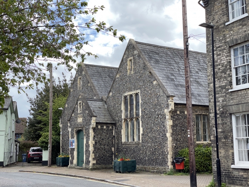
School Hall
TL 8640 4/144
II GV
2.
Flint with stone dressings. Engraved above central porch "Church of England
Schools, 1847". Twin-gabled building with 2 interior bays divided by 3
tall cast iron columns. Later false ceiling.
Church of All Saints, Nos 14 to 25 (consec) The School Hall and
Nos 26 and 27 Nos 29 and 30 form a group.
Listing NGR: TL8686940931
External links are from the relevant listing authority and, where applicable, Wikidata. Wikidata IDs may be related buildings as well as this specific building. If you want to add or update a link, you will need to do so by editing the Wikidata entry.


Other nearby listed buildings
