Approximate Location Map
Large Map »
Latitude: 51.6301 / 51°37'48"N
Longitude: -1.1429 / 1°8'34"W
OS Eastings: 459423
OS Northings: 192712
OS Grid: SU594927
Mapcode National: GBR 90M.RW8
Mapcode Global: VHCYH.49N6
Plus Code: 9C3WJVJ4+2V
Entry Name: Shillingford Farmhouse and Attached Walls and Railings
Listing Date: 18 July 1963
Last Amended: 14 May 1986
Grade: II
Source: Historic England
Source ID: 1048094
English Heritage Legacy ID: 248236
ID on this website: 101048094
Location: Shillingford, South Oxfordshire, OX10
County: Oxfordshire
District: South Oxfordshire
Civil Parish: Warborough
Built-Up Area: Warborough
Traditional County: Oxfordshire
Lieutenancy Area (Ceremonial County): Oxfordshire
Church of England Parish: Warborough
Church of England Diocese: Oxford
Tagged with: Farmhouse
WARBOROUGH WHARF ROAD
SU5992 (West side)
Shillingford
11/205 No.8 (Shillingford Farmhouse)
18/07/63 and attached walls and
railings
(Formerly listed as
Shillingford Farmhouse)
GV II
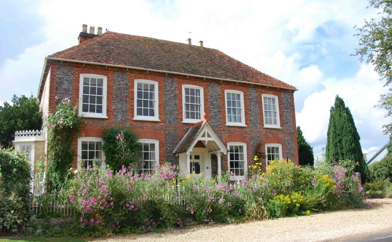
Farmhouse. Early/mid C18. Flared brick with red-brick dressings; coursed clunch
rubble with squared quoins; old plain-tile roof with brick stacks. Double-depth
plan. 2 storeys. Symmetrical 5-window front, in header bond with gauged-brick
segmental arches, has central 6-panel door, with C19 open porch, and 12-pane
sashes in all windows. The brick dentil eaves course continues to rubble sides
and rear. Right side has further segmental-arched sashes; left side has large
C19 canted bay windows with cast-iron ornamental cresting. Double-span hipped
roof with stacks rising from valley. Small C19 rubble and brick wing at rear.
Quoin stone at rear is inscribed "JC 1796". Interior: early/mid C18 stair with
turned balusters and closed string. House is linked by a C19 cast-iron gate to
watching railings and gates, running in front of the house, on a low brick wall,
and to church wall with tiled coping running approx. 50m. to south.
Listing NGR: SU5942392712
External links are from the relevant listing authority and, where applicable, Wikidata. Wikidata IDs may be related buildings as well as this specific building. If you want to add or update a link, you will need to do so by editing the Wikidata entry.


Other nearby listed buildings
