Approximate Location Map
Large Map »
Latitude: 53.3902 / 53°23'24"N
Longitude: -2.9868 / 2°59'12"W
OS Eastings: 334472
OS Northings: 388610
OS Grid: SJ344886
Mapcode National: GBR 73V.XP
Mapcode Global: WH87F.310S
Plus Code: 9C5V92R7+37
Entry Name: Dock Retaining Walls, South Ferry Basin
Listing Date: 19 June 1985
Grade: II
Source: Historic England
Source ID: 1063319
English Heritage Legacy ID: 359539
ID on this website: 101063319
Location: Liverpool, Merseyside, L3
County: Liverpool
Electoral Ward/Division: Riverside
Parish: Non Civil Parish
Built-Up Area: Liverpool
Traditional County: Lancashire
Lieutenancy Area (Ceremonial County): Merseyside
Church of England Parish: Toxteth St Philemon
Church of England Diocese: Liverpool
Tagged with: Building
SJ 38 NW
6/1166
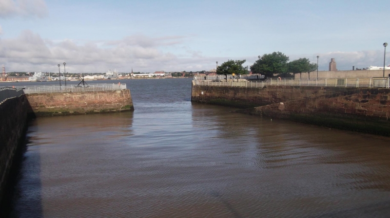
SOUTH FERRY BASIN L3,
Dock retaining Walls
G.V. II
Dock retaining walls. 1821. Sandstone walls with granite copings and opening to river.
Listing NGR: SJ3447288610
External links are from the relevant listing authority and, where applicable, Wikidata. Wikidata IDs may be related buildings as well as this specific building. If you want to add or update a link, you will need to do so by editing the Wikidata entry.


Other nearby listed buildings
