Approximate Location Map
Large Map »
Latitude: 51.8875 / 51°53'15"N
Longitude: -0.5793 / 0°34'45"W
OS Eastings: 497874
OS Northings: 221951
OS Grid: SP978219
Mapcode National: GBR F3L.QC6
Mapcode Global: VHFRB.XT3D
Plus Code: 9C3XVCQC+27
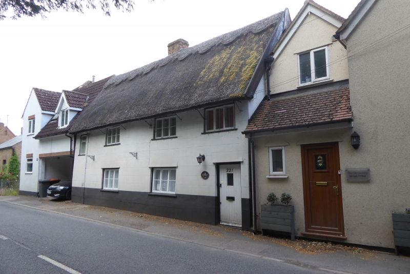
Entry Name: 221, Castle Hill Road
Listing Date: 26 September 1980
Grade: II
Source: Historic England
Source ID: 1114767
English Heritage Legacy ID: 36162
ID on this website: 101114767
Location: Middle End, Central Bedfordshire, LU6
County: Central Bedfordshire
Civil Parish: Totternhoe
Built-Up Area: Totternhoe
Traditional County: Bedfordshire
Lieutenancy Area (Ceremonial County): Bedfordshire
Church of England Parish: Totternhoe
Church of England Diocese: St.Albans
Tagged with: Building Thatched building
1.
5125 TOTTERNHOE CASTLE HILL ROAD
(south side)
Middle End
No 221
SP 9721 31/397
II
2.
C17 with later alterations. Incised stucco. Two storeys. Thatched roof.
Four casement windows. Timber-framing visible to western elevation.
Listing NGR: SP9787421951
External links are from the relevant listing authority and, where applicable, Wikidata. Wikidata IDs may be related buildings as well as this specific building. If you want to add or update a link, you will need to do so by editing the Wikidata entry.


Other nearby listed buildings
