Approximate Location Map
Large Map »
Latitude: 54.5114 / 54°30'41"N
Longitude: -1.1223 / 1°7'20"W
OS Eastings: 456924
OS Northings: 513255
OS Grid: NZ569132
Mapcode National: GBR NJL8.TK
Mapcode Global: WHD77.QVSV
Plus Code: 9C6WGV6H+H3
Entry Name: Church of St Oswald
Listing Date: 25 April 1984
Grade: II*
Source: Historic England
Source ID: 1139807
English Heritage Legacy ID: 59922
ID on this website: 101139807
Location: St Oswald's Church, Newton under Roseberry, Redcar and Cleveland, North Yorkshire, TS9
County: Redcar and Cleveland
Civil Parish: Guisborough
Traditional County: Yorkshire
Lieutenancy Area (Ceremonial County): North Yorkshire
Church of England Parish: Newton under Roseberry
Church of England Diocese: York
Tagged with: Church building
NZ51SE GUISBOROUGH CHURCH LANE
(WEST SIDE)
NEWTON-UNDER-
ROSEBERRY
4/54
Church of St.
Oswald.
II*
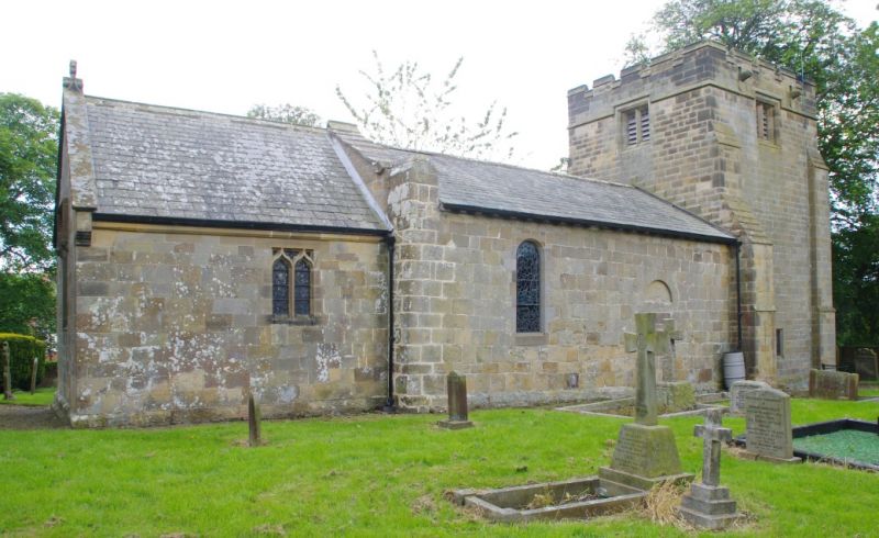
Church, C12, on earlier foundation (north side), with chancel of
1857, west tower of 1901 by Temple Moore and mid/late C17 porch.
Dressed sandstone, except for tower of sandstone ashlar;
Westmorland slate roofs. Blocked round-headed doorway in north
wall of nave. Other openings in nave and chancel inserted or
altered mid C19 to early C20. Gabled porch with Columbus cross
finial, and medieval grave cover used as lintel. Broad, squat
3-stage tower, with embattled parapet, angle buttresses and
Anglo-Saxon carved corner stone in south side of vice.
Internally, the tower is open to full height of nave by
two-centred arch with inner vestry screen wall. C12 chancel
arch, either side of which are squints (10cm square). Traces of
medieval fresco on south wall of nave. Medieval cross-head used
as lintel above piscina of c1900. Norman circular drum-shaped
font, the sides of which have continuous intersecting blind
arcading and imposts and cable moulding at rim.
(V.C.H. North Riding, Vol. II, pp. 275-6; and N. Pevsner,
" .... North Riding", 1966, p.268).
Listing NGR: NZ5692413255
External links are from the relevant listing authority and, where applicable, Wikidata. Wikidata IDs may be related buildings as well as this specific building. If you want to add or update a link, you will need to do so by editing the Wikidata entry.


Other nearby listed buildings
